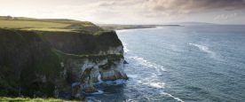
Submit records for Binevenagh AONB

Binevenagh AONB, part of the Causeway Coast and Glens Heritage Trust

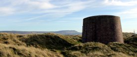
The Binevenagh AONB covers 16,594ha of land and represents a landscape on the edge, a frontier located in the far north-west of the island of Ireland, a place literally looked up to from all sides.


Visit the Binevenagh AONB website to find out more about the region. If you wish to submit records for the area, please use the form below.


Important: if you use this site regularly, please remember to login.

This will give you access to the My Records report which allows you to manage your data.


If you've got lots of records to submit, then we recommend breaking the records up into several batches as it is very easy to accidentally click the back button on the browser and lose the data entered so far.

Please enter the species you saw and any other information about them.

The Species field will autocomplete as you type.
Tip: add an asterisk (*) before the species name if you want to search for part of the name e.g. *porpoise will return both common and harbour porpoise. If you can't find the species using the common name, try using the scientific name. Click on the species you want to choose.)

Determiner: if you have had an expert confirm the identification of a record please add their name in the 'Determiner' field. This will help when the record is being verified.

Step 1
{content}
Select a species first
SpeciesCertaintyDeterminerAbundanceCommentSensitivityPhotos


Please provide the spatial reference of the record
*

By clicking on the map the spatial reference will autofill. The more you zoom in, the more accurate the grid reference.

 *

For example the nearest town, village, park, nature reserve etc.
Please do not enter a postal address as the information you provide will be visible to others.

Notes about using the map:
  • use the + sign on the right hand side of the map to change the base mapping used from Google to OpenStreetMap.
  • To create an accurate and useful record, use your mouse to drag the area of interest to the centre of the map window and use the zoombar on the left hand side to zoom in tight to the area where you made the sighting. When you have zoomed in, click on the location - this will autofill the Spatial Reference box above.

Please provide a date for your sighting(s)
*
Please provide your contact details (note: this information will be used for record verification purposes).
 
 
 *
Any additional recorder(s).
Any additional comments.

Submit records for Antrim Coast & Glens AONB

Antrim Coast & Glens AONB, part of the Causeway Coast and Glens Heritage Trust

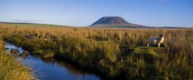
The Antrim Coast & Glens AONB covers 72,489ha of land and contains some of the most beautiful and varied scenery in Northern Ireland, including Rathlin Island, the Glens of Antrim and the coastal area between Larne and Ballycastle.


Visit the Antrim Coast & Glens AONB website to find out more.


Antrim Coast & Glens AONB      


Important: if you use this site regularly, please remember to login.

This will give you access to the My Records report which allows you to manage your data.


If you've got lots of records to submit, then we recommend breaking the records up into several batches as it is very easy to accidentally click the back button on the browser and lose the data entered so far.

Please enter the species you saw and any other information about them.

The Species field will autocomplete as you type.
Tip: add an asterisk (*) before the species name if you want to search for part of the name e.g. *porpoise will return both common and harbour porpoise. If you can't find the species using the common name, try using the scientific name. Click on the species you want to choose.)

Determiner: if you have had an expert confirm the identification of a record please add their name in the 'Determiner' field. This will help when the record is being verified.

Step 1
{content}
Select a species first
SpeciesCertaintyDeterminerAbundanceCommentSensitivityPhotos


Please provide the spatial reference of the record
*

By clicking on the map the spatial reference will autofill. The more you zoom in, the more accurate the grid reference.

 *

For example the nearest town, village, park, nature reserve etc.
Please do not enter a postal address as the information you provide will be visible to others.

Notes about using the map:
  • use the + sign on the right hand side of the map to change the base mapping used from Google to OpenStreetMap.
  • To create an accurate and useful record, use your mouse to drag the area of interest to the centre of the map window and use the zoombar on the left hand side to zoom in tight to the area where you made the sighting. When you have zoomed in, click on the location - this will autofill the Spatial Reference box above.

Please provide a date for your sighting(s)
*
Please provide your contact details (note: this information will be used for record verification purposes).
 
 
 *
Any additional recorder(s).
Any additional comments.

Submit records for the Belfast Hills Partnership

About the Belfast Hills Partnership

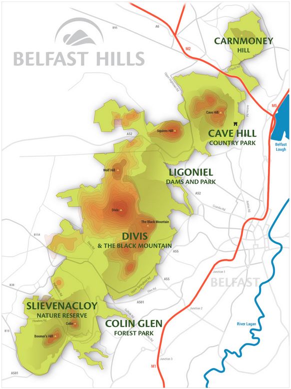
The Belfast Hills Partnership (BHP) is an independent charity which seeks to improve how the hills are managed. They will do this by working with all their partners including local councils, government departments, community groups, nature conservation organisations and businesses committed to caring for the Belfast hills and their people.


The Belfast Hills Partnership acts for all sides and interests in the hills. They bring together statutory bodies with a role to play in the Hills, including the four councils of Belfast, Lisburn, Newtownabbey and Antrim. These are joined by people from farming, the settlements, commercial enterprises and the recreation and environmental sectors.


All these groups have pledged to work together to solve problems and forge new initiatives to benefit the Hills. You can find out more on the Belfast Hills website.


Important: if you use this site regularly, please remember to login.

This will give you access to the My Records report which allows you to manage your data.

If you've got lots of records to submit, then we recommend breaking the records up into several batches as it is very easy to accidentally click the back button on the browser and lose the data entered so far.

Please enter the species you saw and any other information about them.

The Species field will autocomplete as you type.
Tip: add an asterisk (*) before the species name if you want to search for part of the name e.g. *porpoise will return both common and harbour porpoise. If you can't find the species using the common name, try using the scientific name. Click on the species you want to choose.)

Determiner: if you have had an expert confirm the identification of a record please add their name in the 'Determiner' field. This will help when the record is being verified.

Step 1
{content}
Select a species first
SpeciesDeterminerCertaintyAbundanceCommentSensitivityPhotos


Please provide the spatial reference of the record
*

By clicking on the map the spatial reference will autofill. The more you zoom in, the more accurate the grid reference.

 *

For example the nearest town, village, park, nature reserve etc.
Please do not enter a postal address as the information you provide will be visible to others.

Notes about using the map:
  • use the + sign on the right hand side of the map to change the base mapping used from Google to OpenStreetMap.
  • To create an accurate and useful record, use your mouse to drag the area of interest to the centre of the map window and use the zoombar on the left hand side to zoom in tight to the area where you made the sighting. When you have zoomed in, click on the location - this will autofill the Spatial Reference box above.

Please provide a date for your sighting(s)
*
Please provide your contact details (note: this information will be used for record verification purposes).
Your contact details
 
 
 *
Any additional recorder(s).
Any additional comments.

Submit Marine records

Red Cushion Star © Bernard Picton
Picture: Red Cushion Star (Porania pulvillus) © Bernard Picton


Important: if you use this site regularly, please remember to login.

This will give you access to the My Records report which allows you to manage your data.

If you've got lots of records to submit, then we recommend breaking the records up into several batches as it is very easy to accidentally click the back button on the browser and lose the data entered so far.

Please enter the species you saw and any other information about them.

The Species field will autocomplete as you type.
Tip: add an asterisk (*) before the species name if you want to search for part of the name e.g. *porpoise will return both common and harbour porpoise. If you can't find the species using the common name, try using the scientific name. Click on the species you want to choose.)

Determiner: if you have had an expert confirm the identification of a record please add their name in the 'Determiner' field. This will help when the record is being verified.

Sensitivity: It is recommended you only use this facility if you want to protect the location of the species.

Step 1
{content}
Select a species first
SpeciesDeterminerAbundanceCertaintyCommentSensitivityPhotos


Please provide the spatial reference of the record
*

By clicking on the map the spatial reference will autofill. The more you zoom in, the more accurate the grid reference.

 *

For example the nearest town, village, park, nature reserve etc.
Please do not enter a postal address as the information you provide will be visible to others.

Please use the Marine Habitat Classifications described here.

Notes about using the map:
  • use the + sign on the right hand side of the map to change the base mapping used from Google to OpenStreetMap.
  • To create an accurate and useful record, use your mouse to drag the area of interest to the centre of the map window and use the zoombar on the left hand side to zoom in tight to the area where you made the sighting. When you have zoomed in, click on the location - this will autofill the Spatial Reference box above.

Please provide a date for your sighting(s)
*
Please provide your contact details (note: this information will be used for record verification purposes).
Your contact details
 
 
 *
 
Any additional recorder(s).

Submit Dragonfly and Damselfly records

Important: if you use this site regularly, please remember to login.

This will give you access to the My Records report which allows you to manage your data.


Use this page to enter records of dragonflies and damselflies for a single location.


Please tick all the species you saw and any other information about them.

Please note: if you have had an expert confirm the identification of a record please add their name in the 'Determiner' field. This will help when the record is being verified.

Step 1
{content} Select a species first
SpeciesPresentAbundanceDeterminerCertaintyCommentPhotos
Aeshna grandis - Brown Hawker
insect - dragonfly (Odonata)
Add photos
Aeshna juncea - Common Hawker
insect - dragonfly (Odonata)
Add photos
Aeshna mixta - Migrant Hawker
insect - dragonfly (Odonata)
Add photos
Anax ephippiger - Vagrant Emperor
insect - dragonfly (Odonata)
Add photos
Anax imperator - Emperor Dragonfly
insect - dragonfly (Odonata)
Add photos
Anax parthenope - Lesser Emperor
insect - dragonfly (Odonata)
Add photos
Brachytron pratense - Hairy Dragonfly
insect - dragonfly (Odonata)
Add photos
Calopteryx splendens - Banded Demoiselle
insect - dragonfly (Odonata)
Add photos
Calopteryx virgo - Beautiful Demoiselle
insect - dragonfly (Odonata)
Add photos
Coenagrion lunulatum - Irish Damselfly
insect - dragonfly (Odonata)
Add photos
Coenagrion puella - Azure Damselfly
insect - dragonfly (Odonata)
Add photos
Coenagrion pulchellum - Variable Damselfly
insect - dragonfly (Odonata)
Add photos
Cordulegaster boltonii - Golden-ringed Dragonfly
insect - dragonfly (Odonata)
Add photos
Cordulia aenea - Downy Emerald
insect - dragonfly (Odonata)
Add photos
Enallagma cyathigerum - Common Blue Damselfly
insect - dragonfly (Odonata)
Add photos
Ischnura elegans - Blue-tailed Damselfly
insect - dragonfly (Odonata)
Add photos
Ischnura pumilio - Scarce Blue-tailed Damselfly
insect - dragonfly (Odonata)
Add photos
Lestes dryas - Scarce Emerald Damselfly
insect - dragonfly (Odonata)
Add photos
Lestes sponsa - Emerald Damselfly
insect - dragonfly (Odonata)
Add photos
Libellula quadrimaculata - Four-spotted Chaser
insect - dragonfly (Odonata)
Add photos
Orthetrum cancellatum - Black-tailed Skimmer
insect - dragonfly (Odonata)
Add photos
Orthetrum coerulescens - Keeled Skimmer
insect - dragonfly (Odonata)
Add photos
Pyrrhosoma nymphula - Large Red Damselfly
insect - dragonfly (Odonata)
Add photos
Somatochlora arctica - Northern Emerald
insect - dragonfly (Odonata)
Add photos
Sympetrum danae - Black Darter
insect - dragonfly (Odonata)
Add photos
Sympetrum flaveolum - Yellow-winged Darter
insect - dragonfly (Odonata)
Add photos
Sympetrum fonscolombii - Red-veined Darter
insect - dragonfly (Odonata)
Add photos
Sympetrum sanguineum - Ruddy Darter
insect - dragonfly (Odonata)
Add photos
Sympetrum striolatum - Common Darter
insect - dragonfly (Odonata)
Add photos


Your details (please note: this information will be used for record verification purposes only by NIEA and CEDaR staff).
Your contact details
 *
 *
 *
 
Any additional recorder(s) names.
Date of your sighting.
*
Please provide the spatial reference and site name for the record.
*

By clicking on the map the spatial reference will autofill. The more you zoom in, the more accurate the grid reference.

*

For example the nearest town, village, park, nature reserve etc.
Do not enter a postal address as the information you provide will be visible to others.


Notes about using the map:
  • use the + sign on the right hand side of the map to change the base mapping used from Google to OpenStreetMap.
  • To create an accurate and useful record, use your mouse to drag the area of interest to the centre of the map window and use the zoombar on the left hand side to zoom in tight to the area where you made the sighting. When you have zoomed in, click on the location - this will autofill the Spatial Reference box above.

Submit Shieldbug records

Important: if you use this site regularly, please remember to login.

This will give you access to the My Records report which allows you to manage your data.


Use this page to enter records of shieldbugs for a single location.


Please tick all the species you saw and any other information about them.

Please note: if you have had an expert confirm the identification of a record please add their name in the 'Determiner' field. This will help when the record is being verified.

Step 1
{content} Select a species first
SpeciesPresentDeterminerCertaintyAbundanceCommentPhotos
Acanthosoma haemorrhoidale - Hawthorn Shieldbug
insect - true bug (Hemiptera)
Add photos
Coreus marginatus - Dock Bug
insect - true bug (Hemiptera)
Add photos
Cyphostethus tristriatus - Juniper Shieldbug
insect - true bug (Hemiptera)
Add photos
Dolycoris baccarum - Hairy Shieldbug
insect - true bug (Hemiptera)
Add photos
Elasmostethus interstinctus - Birch Shieldbug
insect - true bug (Hemiptera)
Add photos
Elasmucha grisea - Parent Bug
insect - true bug (Hemiptera)
Add photos
Eurygaster testudinaria - Tortoise Bug
insect - true bug (Hemiptera)
Add photos
Palomena prasina - Green Shieldbug
insect - true bug (Hemiptera)
Add photos
Pentatoma rufipes - Red-legged Shieldbug
insect - true bug (Hemiptera)
Add photos
Picromerus bidens - Spiked Shieldbug
insect - true bug (Hemiptera)
Add photos
Piezodorus lituratus - Gorse Shieldbug
insect - true bug (Hemiptera)
Add photos
Rhacognathus punctatus - Heather Shieldbug
insect - true bug (Hemiptera)
Add photos
Sehirus luctuosus - Forget-me-not Shieldbug
insect - true bug (Hemiptera)
Add photos
Thyreocoris scarabaeoides - Scarab Shieldbug
insect - true bug (Hemiptera)
Add photos
Troilus luridus - Bronze Shieldbug
insect - true bug (Hemiptera)
Add photos
Zicrona caerulea - Blue Shieldbug
insect - true bug (Hemiptera)
Add photos


Your details (please note: this information will be used for record verification purposes only by NIEA and CEDaR staff).
Your contact details
 *
 *
 *
 
Any additional recorder(s) names.
Date of your sighting.
*
Please provide the spatial reference and site name for the record.
*

By clicking on the map the spatial reference will autofill. The more you zoom in, the more accurate the grid reference.

 *

For example the nearest town, village, park, nature reserve etc.
Please do not enter a postal address as the information you provide will be visible to others.


Notes about using the map:
  • use the + sign on the right hand side of the map to change the base mapping used from Google to OpenStreetMap.
  • To create an accurate and useful record, use your mouse to drag the area of interest to the centre of the map window and use the zoombar on the left hand side to zoom in tight to the area where you made the sighting. When you have zoomed in, click on the location - this will autofill the Spatial Reference box above.

Submit Butterfly records

Important: if you use this site regularly, please remember to login.

This will give you access to the My Records report which allows you to manage your data.


Please tick all the species you saw and any other information about them.

Please note: if you have had an expert confirm the identification of a record please add their name in the 'Determiner' field. This will help when the record is being verified.

Step 1
{content} Select a species first
SpeciesPresentAbundanceDeterminerStage (Butterfly)CertaintyCommentPhotos
Aglais io - Peacock
insect - butterfly
Add photos
Aglais urticae - Small Tortoiseshell
insect - butterfly
Add photos
Anthocharis cardamines - Orange-tip
insect - butterfly
Add photos
Aphantopus hyperantus - Ringlet
insect - butterfly
Add photos
Argynnis paphia - Silver-washed Fritillary
insect - butterfly
Add photos
Boloria euphrosyne - Pearl-bordered Fritillary
insect - butterfly
Add photos
Callophrys rubi - Green Hairstreak
insect - butterfly
Add photos
Celastrina argiolus - Holly Blue
insect - butterfly
Add photos
Coenonympha pamphilus - Small Heath
insect - butterfly
Add photos
Coenonympha tullia - Large Heath
insect - butterfly
Add photos
Colias croceus - Clouded Yellow
insect - butterfly
Add photos
Cupido minimus - Small Blue
insect - butterfly
Add photos
Erynnis tages - Dingy Skipper
insect - butterfly
Add photos
Euphydryas aurinia - Marsh Fritillary
insect - butterfly
Add photos
Favonius quercus - Purple Hairstreak
insect - butterfly
Add photos
Gonepteryx rhamni - Brimstone
insect - butterfly
Add photos
Hipparchia semele - Grayling
insect - butterfly
Add photos
Lasiommata megera - Wall
insect - butterfly
Add photos
Leptidea juvernica - Cryptic Wood White
insect - butterfly
Add photos
Leptidea sinapis - Wood White
insect - butterfly
Add photos
Lycaena phlaeas - Small Copper
insect - butterfly
Add photos
Maniola jurtina - Meadow Brown
insect - butterfly
Add photos
Pararge aegeria - Speckled Wood
insect - butterfly
Add photos
Pieris brassicae - Large White
insect - butterfly
Add photos
Pieris napi - Green-veined White
insect - butterfly
Add photos
Pieris rapae - Small White
insect - butterfly
Add photos
Polygonia c-album - Comma
insect - butterfly
Add photos
Polyommatus icarus - Common Blue
insect - butterfly
Add photos
Pyronia tithonus - Gatekeeper
insect - butterfly
Add photos
Thecla betulae - Brown Hairstreak
insect - butterfly
Add photos
Thymelicus lineola - Essex Skipper
insect - butterfly
Add photos
Thymelicus sylvestris - Small Skipper
insect - butterfly
Add photos
Vanessa atalanta - Red Admiral
insect - butterfly
Add photos
Vanessa cardui - Painted Lady
insect - butterfly
Add photos


Your details (please note: this information will be used for record verification purposes only by NIEA and CEDaR staff).
Your contact details
 *
 *
 *
 
Any additional recorder(s) names.
Date of your sighting.
*
Please provide the spatial reference of the record
*

By clicking on the map the spatial reference will autofill. The more you zoom in, the more accurate the grid reference.

*

For example the nearest town, village, park, nature reserve etc.
Please do not enter a postal address as the information you provide will be visible to others.


Notes about using the map:
  • use the + sign on the right hand side of the map to change the base mapping used from Google to OpenStreetMap.
  • To create an accurate and useful record, use your mouse to drag the area of interest to the centre of the map window and use the zoombar on the left hand side to zoom in tight to the area where you made the sighting. When you have zoomed in, click on the location - this will autofill the Spatial Reference box above.

Submit garden moth trap records

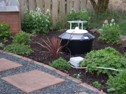
Use this page to enter records of moths caught in a garden moth trap.

This form includes automatic blurring of the spatial reference and site name of the record. This feature is enabled on this form because many people trap in their gardens and when the record is added to the system those details appear in public reports.


Previously, to prevent this happening, the recorder had to mark each species as sensitive (this was not ideal!). Using this form allows you to enter the full details about your records in the knowledge that your home address will not appear in the Explore > All Records reports.


The full information will still be available to CEDaR and verifiers but the public records reports will no longer include the site name and grid reference while the dot on the map will be blurred to 1km.


Important: if you use this site regularly, please remember to login.

This will give you access to the My Records report which allows you to manage your data.


Your details (please note: this information will be used for record verification purposes only by NIEA and CEDaR staff).
Your contact details
 
 
 *
 
Sample Method
 
 
Any additional recorder(s) names.
Date of your sighting.
*


Please add all the species you saw and any other information about them. The species box will auto-complete as you type.

Please note: if you have had an expert confirm the identification of a record please add their name in the 'Determiner' field. This will help when the record is being verified.

Step 1
{content} Select a species first
SpeciesAbundanceDeterminerStage (Moth)CertaintyPhotos


Please provide the spatial reference and site name for the record.
*

By clicking on the map the spatial reference will autofill.

 *

The information you enter will not be included in public reports and the spatial reference will be blurred to 1km. This is to prevent postal addresses appearing in public reports.


Notes about using the map:
  • use the + sign on the right hand side of the map to change the base mapping used from Google to OpenStreetMap.
  • To create an accurate and useful record, use your mouse to drag the area of interest to the centre of the map window and use the zoombar on the left hand side to zoom in tight to the area where you made the sighting. When you have zoomed in, click on the location - this will autofill the Spatial Reference box above.

Submit Moth records

Important: if you use this site regularly, please remember to login.

This will give you access to the My Records report which allows you to manage your data.


Records entered using this page will not be blurred in public reports. If you trap in your garden you may wish to use the page specifically made for submitting records from garden moth traps.


Use this page to enter records of moths for a single location.

Your details (please note: this information will be used for record verification purposes only by NIEA and CEDaR staff).
Your contact details
 
 
 *
 
Sample Method
 
 
Any additional recorder(s) names.
Date of your sighting.
*


Please add all the species you saw and any other information about them. The species box will auto-complete as you type.

Please note: if you have had an expert confirm the identification of a record please add their name in the 'Determiner' field. This will help when the record is being verified.

Step 1
{content} Select a species first
SpeciesAbundanceDeterminerStage (Moth)CertaintyCommentPhotos


Please provide the spatial reference and site name for the record.
*

By clicking on the map the spatial reference will autofill. The more you zoom in, the more accurate the grid reference.

 *

For example the nearest town, village, park, nature reserve etc.
The information you enter will be included in public reports along with the full spatial reference.
Please do not enter a postal address as the information you provide will be visible to others.


Notes about using the map:
  • use the + sign on the right hand side of the map to change the base mapping used from Google to OpenStreetMap.
  • To create an accurate and useful record, use your mouse to drag the area of interest to the centre of the map window and use the zoombar on the left hand side to zoom in tight to the area where you made the sighting. When you have zoomed in, click on the location - this will autofill the Spatial Reference box above.

Squirrels in Northern Ireland

The Northern Ireland Squirrel Forum (NISF) was established to bring together statutory and non-statutory organisations as well as representatives of country parks, private landowners and local volunteer organisations dedicated to protecting the red squirrel in Northern Ireland. The NISF provides an opportunity for the members of the group to feedback details of news, exchange ideas, new research findings, best practice on how to help conserve red and control grey squirrels. 


Sick looking squirrels

If you spot a red squirrel which looks ill, especially if it shows signs of Squirrel pox (see the NISF website for symptoms) please email Squirrels [at] daera-ni.gov.uk (subject: Message%20via%20online%20recording%20form) (Squirrels[at]daera-ni[dot]gov[dot]uk) .  We would appreciate if you can forward any photos of the sick animals to this address also, thank you. 


More information can be found on the NISF web page including links to local Squirrel Groups in your area.


Red Squirrel, copyright Tom Ennis    Grey Squirrel, copyright Tom Ennis


Important: if you use this site regularly, please remember to login.

This will give you access to the My Records report which allows you to manage your data.

Submit your squirrel records using the form below

What did you see?
*

Please select the species you want to submit a record for.

Provide an indication of the abundance.

If you have had an expert confirm the identification of a record please add their name in the 'Determiner' field. This will help when the record is being verified.

*
Sensitivity

This is the precision that the record will be shown at for public viewing

Your details
 *

We will only use your email address if we need to contact you about your record.
If you are logged into the system, please do not lock these values. The information will be auto-filled from your account profile.

 *
 *
 
Please provide the spatial reference and site name for the record.
*

By clicking on the map the spatial reference will autofill. The more you zoom in, the more accurate the grid reference.

 *

For example the nearest town, village, park, nature reserve etc. Please do not enter a postal address as the information you provide will be visible to others.


Notes about using the map:
  • use the + sign on the right hand side of the map to change the base mapping used from maps to satellite images or OpenStreetMap maps.
  • To create an accurate and useful record, use your mouse to drag the area of interest to the centre of the map window and use the zoombar on the left hand side to zoom in tight to the area where you made the sighting. When you have zoomed in, click on the location - this will autofill the Spatial Reference box.