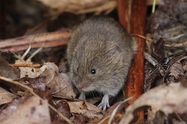
Ireland’s ecosystem just got a bit more diverse, but unfortunately not necessarily for the better. Two vole species are now found in NI: the bank vole (Myodes glareolus) and the field vole (Microtus agrestis - also known as the short-tailed vole). While both species are present throughout England, Scotland and Wales, they are not native in Northern Ireland, and their effects on our ecosystem are yet to be completely understood.
After being originally brought into County Limerick during the construction of the Shannon Hydroelectric Scheme in the late 1920s, the bank vole has continuously spread across Ireland and has now found its way to Crumlin, County Down, Northern Ireland. The field vole is a much more recent arrival, with its origin still unknown, but was first sighted in north Antrim in 2011 and has also been found throughout the Belfast Hills and south Belfast around the Giant's Ring.
While we are still determining the extent of effects these invasive small mammals have, they are likely negative. Bank voles have caused the loss of the native wood mouse across much of the Republic of Ireland and have triggered declines in invertebrate biodiversity. The field vole’s impacts are yet to be studied, but they are known to ring bark young saplings which harms tree health. This behaviour may affect our agriculture sector, especially orchards.
Queen’s University Belfast and Ulster Wildlife are gathering more information and welcome sightings of both species.
Verifying Voles from rodent relatives
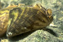
While at first glance, a vole may look incredibly similar to our native wood mouse, there are a few key differences that help to distinguish them:
Wood mice tend to have tails as long as their body whereas vole species have much shorter tails
Vole snouts are much more rounded compared to the wood mouse which has a more pointed snout
Wood mice have much more protrusive and larger ears than voles
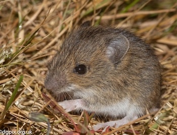
While both of our new vole species look incredibly similar, especially when compared to the wood mouse, there are a few key differences you can take to tell which vole you’re looking at:
The field vole has a shorter tail than the bank vole. The field vole’s tail is about 30% of its total body length as opposed to the bank vole which has a tail 50% its body length
Field voles tend to have a shaggier greyer coat, whereas bank voles are browner with a smoother coat
Recreational fishing provides unique and ample opportunities for biological recording. Employing this widespread recreational activity in order to gather environmental data (often then used for conservation) is something many keen fishers are in favour of, and provides a valuable snapshot of aquatic ecosystems and, crucially, an under-recorded clade of vertebrates.
Autumn 2025 marks the Year 1 pilot of Northern Ireland’s Waxcap/Grassland Fungi recording project with CEDaR. This will be a 3-5 year project, largely restricted to Northern Ireland in it’s first year.
Grassland fungi are an important indicator of rare habitats, long-established and ancient grasslands. The study will focus on the CHEGD grassland fungi, a restricted group. It aims to build capacity by developing a pyramid of expertise, starting with a wide base of interested recorders with knowledge of basic species, then a group of recorders with microscopy training who can confirm finds, followed by a core group with more experience who will sequence critical finds with a portable PCR machine.
Surveying in the first year will focus primarily on County Antrim, with survey efforts broadening as the project develops in later years.
Please enter the species you saw. Include in the comments and any other information about them.
For the comment section please consider the following checklist:
The Centre for Environmental Data and Recording (CEDaR) is based within the Curatorial Department of National Museums NI and is a partnership with NI Environment Agency (NIEA) and the Environmental Recorders’ Group (ERG).
CEDaR has been operational for 30 years and has led the way on the wider recording of a diverse range of species Groups, both within NI and across the island of Ireland. Mammal recording has always been an important element of our activities, and the Centre has been involved with a number of recording projects since 1995.
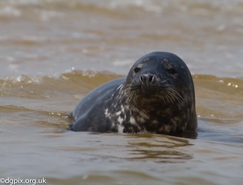
Photos: Danny Gibson
To celebrate the 30-year milestone, and as part of a variety of events, the Centre has launched its latest recording initiative. The NI Mammal Recording Project (2025–29), marks the twenty-fifth anniversary since the completion of its previous bespoke mammal recording scheme (1995–2000), and provides a contemporary focus on our knowledge of the status and distribution of mammal species throughout Northern Ireland.
This latest project will combine the involvement of Citizen Science recording, with current activities based within University Departments, the wider eNGO sector, etc. We encourage all active recorders to continue the submission of their mammal sightings. When verified and validated, these sightings will be collated within the copy of the Recorder 6 database at CEDaR.
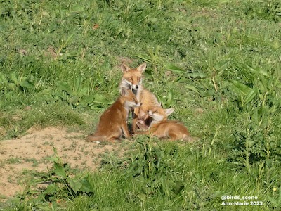
Photo: Ann-Marie 2023
To widen the recording base, and to facilitate currently interested recorders, we anticipate rolling-out a programme of training courses. Watch out, as these will be advertised in future copies of the CEDaR newsletter. If there is a requirement for equipment, e.g., camera traps, etc., you may wish to consider becoming a member of ERG and applying for funding!
Further details for this NEW recording project will become available in due course. In the interim, please continue your recording activities. We are always very appreciative of your efforts and the continued flow of records to the Centre.
Keep a look out for all mammal sightings, both alive and dead, and send through to CEDaR on the form below.
Storms can be spectacular forces of nature which are becoming more intense and frequent due to Climate Change. Though destructive, storms can provide unique opportunities for biological recording. After the passing of a powerful storm, you might find a number of species you would not otherwise see on the shore. Storm Watch aims to capture records of sublittoral species that have been stranded on our shorelines after strong storm events.
Storm photo: D. Wilson CC BY
What to look out for
Tunicates, sea stars, skate eggs, scallops, seaweeds and other marine species are frequently stranded on the shoreline after strong winds and rough seas. Wearing protective gloves and weather appropriate gear, take a look through some of the flotsam and jetsam to see what species washed up.
Storms are dangerous, especially on the coast! It is important to wait for weather warnings to pass, conditions to before venturing out onto the shore. If you find a seal, dolphin, whale, shark or sea turtle stranded after a storm do not approach them and keep any pets with you under control. Call DAERA Marine and Fisheries Division: 028 70823600, or for a live or injured seal call Exploris 07701372623 or 028 4272 8062. DAERA Stranding Protocols
Important: if you use this site regularly, please remember to login.
This will give you access to the My Records report which allows you to manage your data.
Invasive non native species are a great threat to biodiversity. The ecological/economic impacts can be huge and have far reaching consequences in terms of damage caused. Better understanding is needed to limit this impact.
This year Field Studies Council (FSC) Derrygonnelly have successfully obtained funding through the NIEL NGO Challenge Fund to deliver an exciting project called Invaders of the natural kind. Through partnership with Fermanagh District Council (FDC) and the Centre for Environmental Data and Recording (CEDaR) we hope to help tackle the problem of invasives in the Fermanagh district.
Many mammals are finding life very difficult. We need you to tell us about any mammals you spot by submitting records online. Records should have photographs but, don’t worry, if you can’t take a photo, your record will still be valuable.
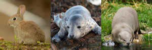
We invite members of the public to assist with a new survey throughout 2026, to investigate the distribution of squirrels and the pine marten in Ireland. CEDaR has teamed up with University of Galway, Ulster Wildlife, Vincent Wildlife Trust and the National Biodiversity Data Centre in this research, which follows similar surveys conducted in 2007, 2012 and 2019. Since their introduction in 1911, the grey squirrel has spread throughout a large area of the island of Ireland. The red squirrel, impacted by competition and disease spread by the greys, has previously struggled and retracted in range as a result. In the most recent surveys in 2012 and 2019, however, the grey squirrel had been knocked back in certain areas, and this has been attributed to the recovery of another native species, the pine marten. In 2019, the red squirrel had recovered in some areas in the midlands, however, the grey squirrel continued to spread in the southwest and northwest.
Please submit sightings of red squirrels, grey squirrels and pine martens via the online recording form, and include a photograph, if you have one. Besides the location we would be interested to hear any other details, such as how often you see the animal, or if you have noticed a change in the frequency of seeing the animals, using the ‘Comments’ box. We may contact you subsequently to help verify sightings.
Fur Colour: Red-brown, chestnut or grey-brown fur, with a white belly. Tail can vary in colour, and can be dark, red or blonde. They often have prominent ear tufts, which are most obvious during the winter months.
Comments: Red squirrels are relatively shy and elusive, and are most frequently seen up in the canopy of trees.
Fur Colour: Grey fur, occasionally chestnut coloured on the back and haunches, particularly in the summer. Tail is grey, with a white fringe to the hair. No ear tufts
Comments: Grey squirrels are bolder than red squirrels, and so tend to be more conspicuous. They spend more of their time on the woodland floor.
Fur Colour: Dark brown fur, with a large cream or yellow coloured throat patch.
Comments: They are typically nocturnal, and very good climbers. They could be confused with other mustelid carnivores, such as the American mink, but pine marten are larger and have prominent rounded ears. Mink have darker fur, and are more frequently found close to water.
Important: if you use this site regularly, please remember to login.
This will give you access to the My Records report which allows you to manage your data.
Mammals are difficult to record because they are rarely seen; we often need to use other clues, such as tracks or scats, to help confirm their presence in an area. They can be a great indicator of the quality of natural habitats and biodiversity within Northern Ireland. However, many threats endanger mammals in the modern world and CEDaR would like to find out what is happening to the populations of our furry friends. Where do they live? Are we doing enough to ensure they are healthy? Have they had to move because we are encroaching on their homes?
Important: if you use this site regularly, please remember to login.
This will give you access to the My Records report which allows you to manage your data.
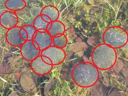
The Big Spawn Count project is into its second year in Northern Ireland! This project is part of a larger national project which involves you going out to your local or garden waterbody (e.g. pond) and looking for frog spawn!


, Belfast Lough © R. Wilson")


], via Wikimedia Commons")
 or GFDL http://www.gnu.org/copyleft/fdl.html], from Wikimedia Commons")