Submit single record (all species)

Important: if you use this site regularly, please remember to login.

This will give you access to the My Records report which allows you to manage your data.

What did you see?
*

Tip - add an asterisk (*) before the species name if you want to search for part of the name e.g. *porpoise will return both common and harbour porpoise. If you can't find the species using the common name, try using the scientific name. Click on the species you want to choose.)

Provide an indication of the abundance.

If you have had an expert confirm the identification of a record please add their name in the 'Determiner' field. This will help when the record is being verified.

*
 
It is recommended you only use the following facility if you want to protect the location of this species.
Sensitivity

This is the precision that the record will be shown at for public viewing


Your details
 *
 *
 *

We will only use your email address if we need to contact you about your record.
If you are logged into the system, please do not lock these values. The information will be auto-filled from your account profile.


Please provide the spatial reference and site name for the record.
*

By clicking on the map the spatial reference will autofill. The more you zoom in, the more accurate the grid reference.

 *

For example the nearest town, village, park, nature reserve etc. Please do not enter a postal address as the information you provide will be visible to others.


Notes about using the map:
  • use the + sign on the right hand side of the map to change the base mapping used from maps to satellite images or OpenStreetMap maps.
  • To create an accurate and useful record, use your mouse to drag the area of interest to the centre of the map window and use the zoombar on the left hand side to zoom in tight to the area where you made the sighting. When you have zoomed in, click on the location - this will autofill the Spatial Reference box.
 

Ladybird Survey

Important: if you use this site regularly, please remember to login.

This will give you access to the My Records report which allows you to manage your data.


Use this page to enter records of ladybirds for a single location. To find out more about Ladybirds see the Ladybirds of Ireland website.


There is a new Harlequin Ladybird ID sheet available for download to help with identification of this invasive species.


Please tick all the species you saw and any other information about them.

Please note: if you have had an expert confirm the identification of a record please add their name in the 'Determiner' field. This will help when the record is being verified.

Step 1
{content} Select a species first
SpeciesPresentAbundanceDeterminerCertaintyCommentPhotos
10-spot Ladybird - Adalia decempunctata Add photos
11-spot Ladybird - Coccinella undecimpunctata Add photos
12-spot Ladybird - Vibidia duodecimguttata Add photos
14-spot Ladybird - Propylea quattuordecimpunctata Add photos
18-spot Ladybird - Myrrha octodecimguttata Add photos
19-Spot Ladybird - Anisosticta novemdecimpunctata Add photos
22-spot Ladybird - Psyllobora vigintiduopunctata Add photos
24-spot Ladybird - Subcoccinella vigintiquattuorpunctata Add photos
2-spot Ladybird - Adalia bipunctata Add photos
7-spot Ladybird - Coccinella septempunctata Add photos
Cream-spot Ladybird - Calvia quattuordecimguttata Add photos
Eyed Ladybird - Anatis ocellata Add photos
Heather Ladybird - Chilocorus bipustulatus Add photos
Hieroglyphic Ladybird - Coccinella hieroglyphica Add photos
Larch Ladybird - Aphidecta obliterata Add photos
Orange Ladybird - Halyzia sedecimguttata Add photos
Seven-Spot Ladybird - Coccinella septempunctata Add photos
Striped Ladybird - Myzia oblongoguttata Add photos
Ten-Spot Ladybird - Adalia decempunctata Add photos
Two-Spot Ladybird - Adalia bipunctata Add photos
Water Ladybird - Anisosticta novemdecimpunctata Add photos


Your details (please note: this information will be used for record verification purposes only by NIEA and CEDaR staff).
Your contact details
 *
 *
 *


Any additional recorder(s) names.
Date of your sighting.
*
Please provide the spatial reference and site name for the record.
*

By clicking on the map the spatial reference will autofill. The more you zoom in, the more accurate the grid reference.

*

For example the nearest town, village, park, nature reserve etc.
Do not enter a postal address as the information you provide will be visible to others.


Notes about using the map:
  • use the + sign on the right hand side of the map to change the base mapping used from Google to OpenStreetMap.
  • To create an accurate and useful record, use your mouse to drag the area of interest to the centre of the map window and use the zoombar on the left hand side to zoom in tight to the area where you made the sighting. When you have zoomed in, click on the location - this will autofill the Spatial Reference box above.

Grasshopper Survey

What have you seen hopping about?!

Submit your grasshopper records below and you’ll be contributing to the Northern Ireland survey effort for this species! We only have a few species, so that should make ID-ing them simple! Visit your site once in September and once again in October to see if they’re still hopping about.


Tip: taking a sweep net (if you have one) and combing long grassland will help track these insects down.


Download the recording form here

Download the survey methodology here

Identification

For help with identification and further information on these species, please visit the Orthoptera Recording Scheme website and visit their ‘Species Accounts’ tab:  https://www.orthoptera.org.uk/home


Orthoptera and allied insects website (external link)


Important: if you use this site regularly, please remember to login.

This will give you access to the My Records report which allows you to manage your data.


Please tick all the species you saw and any other information about them.

Please note: if you have had an expert confirm the identification of a record please add their name in the 'Determiner' field. This will help when the record is being verified.

Step 1
{content}
Select a species first
SpeciesPresentGrass height (cm)AbundanceDeterminerCommentSensitivityPhotos
Chorthippus brunneus - Field Grasshopper
Add photos
Myrmeleotettix maculatus - Mottled Grasshopper
Add photos
Omocestus viridulus - Common Green Grasshopper
Add photos
Tetrix subulata - Slender Ground-hopper
Add photos
Tetrix undulata - Common Ground-hopper
Add photos


Your details (please note: this information will be used for record verification purposes only).
*
Any additional recorder(s) names.
Weather Conditions
Date and time of your sighting.
*
Please provide the spatial reference and site name for the record.
*

By clicking on the map the spatial reference will autofill. The more you zoom in, the more accurate the grid reference.

*

For example the nearest town, village, park, nature reserve etc.
Do not enter a postal address as the information you provide will be visible to others.


Notes about using the map:
  • use the + sign on the right hand side of the map to change the base mapping used from Google to OpenStreetMap.
  • To create an accurate and useful record, use your mouse to drag the area of interest to the centre of the map window and use the zoombar on the left hand side to zoom in tight to the area where you made the sighting. When you have zoomed in, click on the location - this will autofill the Spatial Reference box above.

Cuckoo Survey

Mark the return of Spring by listening out for the cuckoo!

Help record what is for many the distinctive sound of Spring – the call of the cuckoo.

If you see or hear a cuckoo please submit your record below.


© Anthony McGeehan, www.facebook.com/anthonymcgeehan


Important: if you use this site regularly, please remember to login.

This will give you access to the My Records report which allows you to manage your data.

Please provide as much information as possible about your Cuckoo sighting(s).
Your details (please note: We will only use your email address if we need to contact you about your record.
If you are logged into the system, please do not lock these values. The information will be auto-filled from your account profile. ).
Your contact details
 *
 *
 *
 
Any additional recorder(s) names.
Date of your sighting.
*
Please provide the spatial reference and site name for the record.
*

By clicking on the map the spatial reference will autofill. The more you zoom in, the more accurate the grid reference.

*

For example the nearest town, village, park, nature reserve etc.
Do not enter a postal address as the information you provide will be visible to others.


Notes about using the map:
  • use the + sign on the right hand side of the map to change the base mapping used from Google to OpenStreetMap.
  • To create an accurate and useful record, use your mouse to drag the area of interest to the centre of the map window and use the zoombar on the left hand side to zoom in tight to the area where you made the sighting. When you have zoomed in, click on the location - this will autofill the Spatial Reference box above.

Barn Owl Project

Help Ulster Wildlife’s barn owl project, Be There for Barn Owls.

We need to know more about the barn owl in order to turn around its declining population in Northern Ireland. We use sightings to help identify where barn owls may be nesting in order to protect the nest site and enhance foraging habitat where it is most needed.

If you see or hear a barn owl please submit your record below


Barn Owl © Richard Bowler
Picture: Barn Owl © Richard Bowler


Honey-coloured back & wings and white underneath with a white heart-shaped face, the barn owl is a distinctive farmland bird but rarely seen in daylight in Northern Ireland. Most often reported as a large, white, ghost-like bird seen in car headlights at night. Only about 250mm from head to feet, broad wings and long wingspan make it appear much larger in flight.

Found throughout Northern Ireland but seem to avoid higher ground; can be seen throughout the year hunting for small mammals on open countryside (not within woods).

Most often confused with long-eared owl; our other resident nocturnal owl in Northern Ireland


In headlights © Barn Owl Trust
Picture: In headlights © Barn Owl Trust


Please provide as much information as possible.
Occurrence attribute occAttr:547 not found.Both checkboxes can be selected if required

Click to hear barn owl sounds: Barn owl screech/Chicks snoring


Occurrence attribute occAttr:541 not found.Occurrence attribute occAttr:543 not found.
Your details (please note: We will only use your email address if we need to contact you about your record.
If you are logged into the system, please do not lock these values. The information will be auto-filled from your account profile. ).
 *
 *
 
 *
 *
 *
Any additional recorder(s) names.
Date of your sighting.
*
*
Barn owl sites
*
Typical barn owl pellet (held in hand)

Barn Owl Pellet

*
Select a record sensitivity (recommended if you suspect a roost/nesting site or you found pellets)
Sensitivity

This is the precision that the record will be shown at for public viewing

*

By clicking on the map the spatial reference will autofill. The more you zoom in, the more accurate the grid reference.

*

For example the nearest town, village, park, nature reserve etc.
Please do not enter a postal address as the information you provide will be visible to others.


Notes about using the map:
  • use the + sign on the right hand side of the map to change the base mapping used from Google to OpenStreetMap.
  • To create an accurate and useful record, use your mouse to drag the area of interest to the centre of the map window and use the zoombar on the left hand side to zoom in tight to the area where you made the sighting. When you have zoomed in, click on the location - this will autofill the Spatial Reference box above.


Hedgehog Survey

 Laurie Campbell


Important: if you use this site regularly, please remember to login.

This will give you access to the My Records report which allows you to manage your data.


Please provide as much information as possible about your Hedgehog sighting(s).
Occurrence attribute occAttr:5 not found.

Please note: if you have had an expert confirm the identification of a record please add their name in the 'Determiner' field. This will help when the record is being verified.

Your details.
Your contact details
 *
 *
 *
 
Any additional recorder(s) names.
Date of your sighting.
*
Please provide the spatial reference and site name for the record.
*

By clicking on the map the spatial reference will autofill. The more you zoom in, the more accurate the grid reference.

*

For example the nearest town, village, park, nature reserve etc.
Do not enter a postal address as the information you provide will be visible to others.


Notes about using the map:
  • use the + sign on the right hand side of the map to change the base mapping used from Google to OpenStreetMap.
  • To create an accurate and useful record, use your mouse to drag the area of interest to the centre of the map window and use the zoombar on the left hand side to zoom in tight to the area where you made the sighting. When you have zoomed in, click on the location - this will autofill the Spatial Reference box above.

Urban Fox Survey

Urban Fox Survey

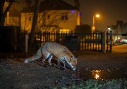
The Urban Fox Survey invites the public to help gather information on Red Fox distribution and expand the knowledge on their relationship with urban environments in Ireland.


Fox picture

Photo: Jamie Hall


Why do we need an 
Urban Fox Survey?

The urban ecology of our wild animals has become increasingly relevant with the spread of urbanisation across the globe. Red Foxes are a prime example of a species learning to adapt to these rapidly changing environments. Understanding their distribution and behaviour across Irish urban areas can shed light on the needs of the animals and the potential of cities to provide for them.

This project will provide valuable data for conservation planning in Ireland and finding solutions for potential human/wildlife conflicts. Our study will focus on the 7 most populated cities/towns across the island of Ireland; Dublin, Belfast, Cork, Limerick, Derry, Galway, and Waterford.


The Red Fox

Red Foxes (Vulpes vulpes) are widespread across Ireland and are characterised by their red fur, bushy tails and dog-like appearance.
This versatile species is primarily nocturnal with a diverse diet which allows it to exploit a wide range of habitats. As omnivorous opportunists, urban foxes feed mostly on scavenged meat, invertebrates, fruit, and anthropogenic food in cities.

Fox activity increases during mating season in January and February and vixens birth cubs between March and April. Urban foxes are frequent visitors to residential areas and often seek gardens to raise cubs.
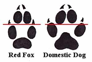


Signs of Foxes

Evidence of fox activity can be found in various forms, including tracks, scat, prey remains, fur clumps, and trampled flowerbeds.

The paw prints of foxes vary from dogs with a more oval pad pattern, with the central digits sitting in front of the outer pair.

Due to their broad diet, fox scat can be tightly packed with a range of contents including fur, bone shards, feathers, seeds, and beetle chitin. They can be differentiated from dog faeces by the presence of a tapered curl at the end. Foxes can harbour parasites so we recommend you don’t handle their droppings!


footprint comparison

Credit: Marc Baldwin


CONTACT US

For any queries regarding the Urban Fox Survey project, please email Urbanfoxsurvey [at] gmail.com (Urbanfoxsurvey[at]gmail[dot]com)

Please consider supporting the project further by following the following social media platforms!

Facebook link Instagram link X link 


Please provide as much information as possible about your Fox sighting(s).
What was observed?Occurrence attribute occAttr:5 not found.
Occurrence attribute occAttr:1142 not found.

Please note: if you have had an expert confirm the identification of a record please add their name in the 'Determiner' field. This will help when the record is being verified.

Your details.
Your contact details
 *
 *
 *


Any additional recorder(s) names.

Date of your sighting.
*
*
Please provide the spatial reference and site name for the record.
*

By clicking on the map the spatial reference will autofill. The more you zoom in, the more accurate the grid reference.

*

For example the nearest town, village, park, nature reserve etc.
Do not enter a postal address as the information you provide will be visible to others.

*

Notes about using the map:
  • use the + sign on the right hand side of the map to change the base mapping used from Google to OpenStreetMap.
  • To create an accurate and useful record, use your mouse to drag the area of interest to the centre of the map window and use the zoombar on the left hand side to zoom in tight to the area where you made the sighting. When you have zoomed in, click on the location - this will autofill the Spatial Reference box above.