Earth Science Conservation Review
| Belmore, Ballintempo & Tullybrack Uplands; Boho | Fermanagh |
| Site Type: | Karst |
| Site Status: | local interest |
| Council area: | Fermanagh District Council |
| Grid Reference: | H1244 |
| Google maps: | 54.34503,-7.81546 |
| Rocks | |
|---|---|
| Rock Age: | Quaternary, Carboniferous (Asbian, Holocene, Visean) |
| Rock Name: | Carn Limestone Member, Dartry Limestone Formation, Glenade Sandstone Formation, Glencar Limestone Formation, Knockmore Limestone Member, Meenymore Formation |
| Rock Type: | Chert, Limestone, Shale |
| Interest | |
| Minerals: | Calcite |
| Other interest: | bedding, fault, joints, rift, breakdown, clastic sediments, doline, drift, flowstone, gour pool, maze cave, organic sediments, sinkhole, soft calcite, speleothem, stalactite, stalagmite, straw |
Summary of site:
Boho Cave is unique in Northern Ireland. It is our only example of a maze cave, a cave system with an intricate network of passages defined by the pattern of joints (natural fractures) in the Dartry Limestone. The cave is centred on Boho village in the Aghanaglack valley, north of the Belmore Mountain uplands, and the immediate area also includes Pollnagollum Coolarkan Cave (not to be confused with the three other Pollnagollums in the area).
This is one of the classic caving areas of Ireland, brought to prominence because it was mentioned by the inimitable Edouard Alfred Martel, the French cave explorer, in his book describing his 1895 adventures in Irish and British caves. His description of the cave, however, is so loose that it is unsure whether Boho or Pollnagollum Coolarkan is being described.
The catchment for Boho Cave is an area of roughly 16kmē of high ground bisected by the Aghanaglack valley which provides a copious flow of water for most of the year. It includes the northern slopes of Belmore Mountain to the south, extends to the watershed of Dooletter col to the west, and incorporates the extensively forested, lough-dotted Aghanaglack uplands to the north and west. This area is floored by the Glenade Sandstone Formation which channels all its surface water into the Aghanaglack River. About 2.5km west south west of Boho the geology of the river bed changes as it descends steeply, crossing from the sandstone on to the Meenymore Formation limestones and mudstones for around 250m followed by 100m of blue grey limestones and dark shales of the Carn Limestone Member. At this point it flows on to the Dartry Limestone occupying the low ground. Here the limestone is a pure grey rock with many nodules of insoluble chert (a microscopically crystalline form of quartz). The river maintains its surface flow for a further 2km but around 100m upstream from the main road junction in Boho village it starts to drain into a series of impenetrable joints in its bed, presumed to feed a constantly waterlogged network of joints and bedding planes (a phreatic system) in the limestone. The water reappears at a resurgence in the river bed below the waterfall in Boho Ravine, around 100m from the main Quarry Entrance to Boho Cave.
Downstream are a further four springs, two on the north bank and two on the south. Dye testing the water in Pollnagollum Coolarkan Cave has confirmed its reappearance at the two resurgences on the south bank. The pair on the north bank are presumed to originate from Pollkeeran and Pollbeg over 2km to the north but this has not been confirmed.
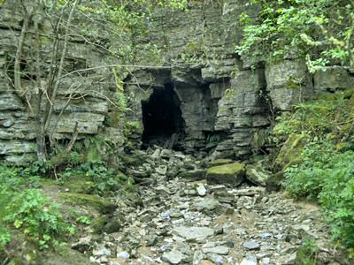
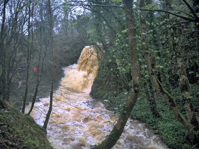
In normal weather conditions the river sinks well upstream and is not seen again until it reappears at the foot of the ravine, but at times of high water flow it feeds joints just upstream of the main sink and drains into the northern cave passages. As flow increases, the river reaches the main sink in the river bed and enters the Main Stream Passage to emerge at the cave entrance in the old quarry or to flow north along a passage glorying in the name of the Sewerage System (via the Septic Tank)! When water does spill into the quarry it drains across the floor towards the ravine forming a waterfall. In extreme conditions the river completely floods the main sink and surges into the adjacent field where it can reach depths of 3m before draining into the numerous shake holes (depressions caused by partial collapse of the limestones beneath).
Boho Cave is an extensive network of rectilinear, mostly narrow passages developed along joints in the Dartry Limestone. Joints are formed by the release of stress stored in the rocks during periods of regional compression and they open into fractures, normally in two well-defined, cross-cutting sets, as the rock is unloaded by the stripping effects of erosion. Unlike faults, there is no discernible movement along or across joints. Corrosive acidic groundwater penetrates these fractures, progressively widening them until they become passable. At Boho the cave plan clearly reveals two joint sets roughly at right angles trending east-north-east / west-south-west and north-north-west / south-south-east. The beds are gently inclined to the south west. Features of the passages are prominent thin ledges (a few cm thick) formed of insoluble chert nodules. There are seven entrances to the major features of the cave and a similar number of lesser importance. The Quarry Entrance and the Main Sink in the river are the most used access points.
The north-east parts of the system, Formation Passage and Coleraine Chamber, contain the best calcite formations, including stalactites, stalagmites, stalactite straws, flowstone, curtains, rimstone pools, soft calcite and canopies. There are a few chambers in the system including two, Henry's Hall and Coleraine Chamber, exceeding 30m in length. Organic debris accumulates between the boulders that litter the chamber floors and soft sediment fills some of the joints.
The only other major cave in the area is Pollnagollum Coolarkan, already mentioned, which consists of a single south-south-easterly trending passage around 85m long, averaging about 5m wide and 3m high. It has a dramatic entrance at the bottom of a substantial shake hole washed by a 12m waterfall. The stream runs along the floor of the passage swinging from side to side before vanishing behind the second boulder choke that marks the end of the passage. Attempts to force the choke have so far proved unsuccessful. There is a suggestion that this cave was formed by the concentrated flow of meltwater on the edge of an ice sheet that occupied the Aghanaglack Valley. While possible, there is little real supporting evidence.
Boho Cave is important because it is the only joint-controlled maze cave in Northern Ireland, with all that implies for its speleogenesis (formation).
Boho is a cave much used by guided educational parties studying the local environment and by casual visitors, but exploration should never be undertaken lightly. In wet weather the narrow passages flood quickly and at these times the cave is extremely dangerous and should be avoided. Heavy flood pulses have been known to inundate the cave up to 24 hours after heavy rain has ceased.
Threats include dumping and the seepage of human waste and farm effluent into the system. The reactivation of quarrying is now a receding anxiety since ownership has transferred to Fermanagh District Council.
| Enlander, I., Dempster, M. & Doughty, P., 2025. Belmore, Ballintempo & Tullybrack Uplands; Boho, County Fermanagh, site summary. [In] Earth Science Conservation Review. https://www.habitas.org.uk/escr/summary.php?item=1159. Accessed on 2025-04-03 |
| Previous Site | Next Site |


