The Irish Stoat Survey invites the public to report sightings of the Irish Stoat throughout Ireland. We welcome any observations of stoats, including live animals or dead specimens such as roadkill.
Irish Stoat Survey
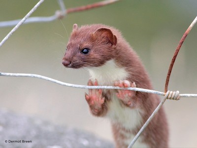
Although the Irish stoat is believed to have been continually present on the island of Ireland for at least 12,500 years, there is little reliable information on its population. They are elusive mammals, who are rarely seen, and who leave few field tracks and signs, such as hair or droppings. They often avoid the standard monitoring methods used for other mammals.
The survey is a collaborative project between Vincent Wildlife Trust, National Biodiversity Data Centre, University of Galway and the Centre for Environmental Data and Recording (Northern Ireland). Financial assistance for this survey was provided by the Irish Environmental Network and National Parks and Wildlife Service.

The Irish Stoat
The subspecies of Irish stoat differs from other stoats in the rest of Europe because it does not turn white in winter, and the line dividing the chestnut-coloured upper fur and the creamy-coloured fur on its belly is usually irregular. However, like all stoats, it has a distinctive black tip to its tail, a long sinuous body, short legs and a flattened head. There are no weasels in Ireland, so the stoat fills the niche occupied by both species in other places.
Mustelid ID Guide (available here)
The Irish stoat can be mistaken for other small mustelids, particularly at dusk or when it is moving quickly. Use this ID guide to differentiate the Irish stoat from pine marten, mink, ferret and otter.