Marine Biodiversity Data Portal - NI

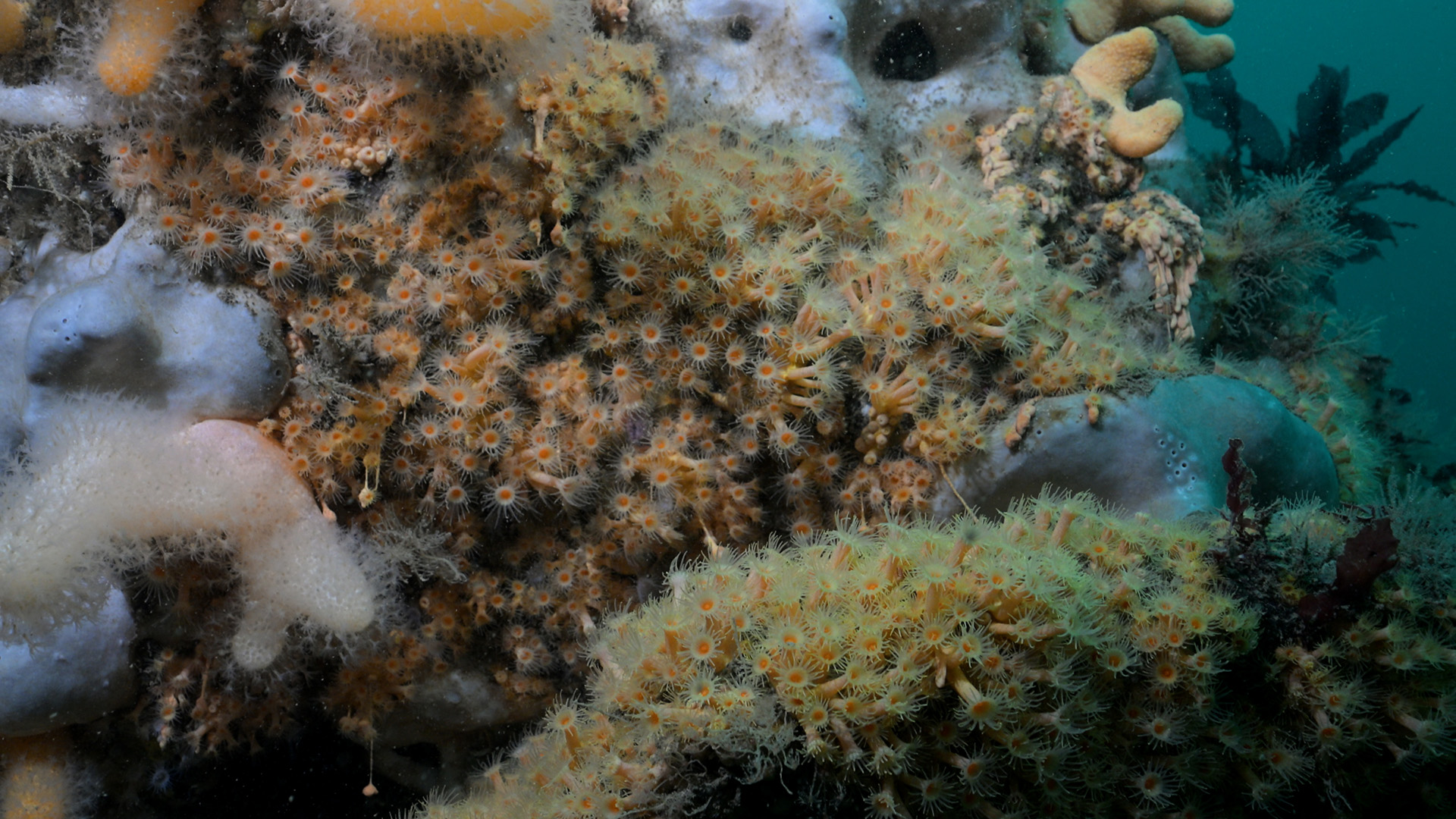
Ruecallan Archway, Rathlin Island
Survey number: 782 Event number: 20250518/01 Date: 2025-05-18 GPS: 55.30788,-6.26920. Depth: -20.0 to -32.0 m. [ View map ]
Site Description: Vertical limestone wall with archway on Rathlin's north wall. There is a small cave with muddy bottom in the wall.
 |
 |
 |
 |
 |
 |
 |
 |
 |
Species list (73 species recorded):
PORIFERA
Sycon sp.
Dysidea fragilis
Pachymatisma johnstonia
Dercitus bucklandi
Axinella dissimilis
Axinella infundibuliformis
Raspailia hispida
Raspailia ramosa
Stelligera stuposa
Polymastia boletiformis
Polymastia penicillus
Sphaerotylus renoufi
Tethya citrina
Iophonopsis nigricans
Lissodendoryx jenjonesae
Hemimycale columella
Hymedesmia paupertas
Hymedesmia rathlinia
Myxilla fimbriata
Myxilla incrustans
Desmacella cf. annexa
Haliclona urceolus
Haliclona viscosa
CNIDARIA
Tubularia indivisa
Halecium halecinum
Tamarisca tamarisca
Nemertesia antennina
Nemertesia ramosa
Aglaophenia tubulifera
Obelia geniculata
Alcyonium digitatum
Alcyonium hibernicum
Virgularia mirabilis
Synarachnactis lloydii
Parazoanthus anguicomus
Parazoanthus axinellae
Actinothoe sphyrodeta
Corynactis viridis
Caryophyllia inornata
Caryophyllia smithii
ANNELIDA
Filograna implexa
CRUSTACEA
Adna anglica
MOLLUSCA
Calliostoma zizyphinum
Hinia (Hima) incrassata
Polycera faeroensis
Edmundsella pedata
Amphorina farrani
Facelina auriculata
BRYOZOA
Crisia denticulata
Crisia eburnea
Bugulina flabellata
Caberea boryi
Cellaria sp.
ECHINODERMATA
Henricia oculata
TUNICATA
Clavelina lepadiformis
Aplidium nordmanni
Aplidium punctum
Didemnidae sp.
Ascidiella aspersa
Ascidia mentula
Polycarpa pomaria
Dendrodoa grossularia
PISCES
Thorogobius ephippiatus
RHODOPHYTA
Corallina officinalis
Dilsea carnosa
Heterosiphonia plumosa
Cryptopleura ramosa
Delesseria sanguinea
Drachiella heterocarpa
Phycodrys rubens
Odonthalia dentata
CHROMOPHYTA
Laminaria hyperborea
Saccorhiza polyschides
Sycon sp.
Dysidea fragilis
Pachymatisma johnstonia
Dercitus bucklandi
Axinella dissimilis
Axinella infundibuliformis
Raspailia hispida
Raspailia ramosa
Stelligera stuposa
Polymastia boletiformis
Polymastia penicillus
Sphaerotylus renoufi
Tethya citrina
Iophonopsis nigricans
Lissodendoryx jenjonesae
Hemimycale columella
Hymedesmia paupertas
Hymedesmia rathlinia
Myxilla fimbriata
Myxilla incrustans
Desmacella cf. annexa
Haliclona urceolus
Haliclona viscosa
CNIDARIA
Tubularia indivisa
Halecium halecinum
Tamarisca tamarisca
Nemertesia antennina
Nemertesia ramosa
Aglaophenia tubulifera
Obelia geniculata
Alcyonium digitatum
Alcyonium hibernicum
Virgularia mirabilis
Synarachnactis lloydii
Parazoanthus anguicomus
Parazoanthus axinellae
Actinothoe sphyrodeta
Corynactis viridis
Caryophyllia inornata
Caryophyllia smithii
ANNELIDA
Filograna implexa
CRUSTACEA
Adna anglica
MOLLUSCA
Calliostoma zizyphinum
Hinia (Hima) incrassata
Polycera faeroensis
Edmundsella pedata
Amphorina farrani
Facelina auriculata
BRYOZOA
Crisia denticulata
Crisia eburnea
Bugulina flabellata
Caberea boryi
Cellaria sp.
ECHINODERMATA
Henricia oculata
TUNICATA
Clavelina lepadiformis
Aplidium nordmanni
Aplidium punctum
Didemnidae sp.
Ascidiella aspersa
Ascidia mentula
Polycarpa pomaria
Dendrodoa grossularia
PISCES
Thorogobius ephippiatus
RHODOPHYTA
Corallina officinalis
Dilsea carnosa
Heterosiphonia plumosa
Cryptopleura ramosa
Delesseria sanguinea
Drachiella heterocarpa
Phycodrys rubens
Odonthalia dentata
CHROMOPHYTA
Laminaria hyperborea
Saccorhiza polyschides
Biotope 1 : Sponges and anemones on vertical circalittoral bedrock. CR.HCR.XFa.SpAnVt (EUNIS A4.139)
PORIFERA
Sycon sp. O
Dysidea fragilis O
Pachymatisma johnstonia F
Dercitus bucklandi O
Axinella dissimilis R
Axinella infundibuliformis F
Raspailia hispida O
Raspailia ramosa R
Stelligera stuposa O
Polymastia boletiformis O
Polymastia penicillus O
Sphaerotylus renoufi O
Tethya citrina R
Iophonopsis nigricans O
Lissodendoryx jenjonesae R
Hemimycale columella O
Hymedesmia paupertas C
Hymedesmia rathlinia R
Myxilla fimbriata R
Myxilla incrustans O
Desmacella cf. annexa O
Haliclona urceolus R
Haliclona viscosa O
CNIDARIA
Tubularia indivisa O
Halecium halecinum C
Tamarisca tamarisca R
Nemertesia antennina C
Nemertesia ramosa O
Aglaophenia tubulifera O
Alcyonium digitatum C
Alcyonium hibernicum R
Parazoanthus anguicomus F
Parazoanthus axinellae C
Actinothoe sphyrodeta C
Corynactis viridis P
Caryophyllia inornata R
Caryophyllia smithii A
ANNELIDA
Filograna implexa R
CRUSTACEA
Adna anglica C
MOLLUSCA
Hinia (Hima) incrassata P
Polycera faeroensis R
Edmundsella pedata R
Amphorina farrani P
BRYOZOA
Crisia denticulata C
Crisia eburnea F
Bugulina flabellata R
Caberea boryi C
Cellaria sp. C
ECHINODERMATA
Henricia oculata R
TUNICATA
Clavelina lepadiformis R
Aplidium nordmanni R
Aplidium punctum F
Didemnidae sp. O
Ascidiella aspersa O
Ascidia mentula R
Polycarpa pomaria O
Dendrodoa grossularia F
RHODOPHYTA
Heterosiphonia plumosa O
Cryptopleura ramosa O
Delesseria sanguinea O
Drachiella heterocarpa O
Sycon sp. O
Dysidea fragilis O
Pachymatisma johnstonia F
Dercitus bucklandi O
Axinella dissimilis R
Axinella infundibuliformis F
Raspailia hispida O
Raspailia ramosa R
Stelligera stuposa O
Polymastia boletiformis O
Polymastia penicillus O
Sphaerotylus renoufi O
Tethya citrina R
Iophonopsis nigricans O
Lissodendoryx jenjonesae R
Hemimycale columella O
Hymedesmia paupertas C
Hymedesmia rathlinia R
Myxilla fimbriata R
Myxilla incrustans O
Desmacella cf. annexa O
Haliclona urceolus R
Haliclona viscosa O
CNIDARIA
Tubularia indivisa O
Halecium halecinum C
Tamarisca tamarisca R
Nemertesia antennina C
Nemertesia ramosa O
Aglaophenia tubulifera O
Alcyonium digitatum C
Alcyonium hibernicum R
Parazoanthus anguicomus F
Parazoanthus axinellae C
Actinothoe sphyrodeta C
Corynactis viridis P
Caryophyllia inornata R
Caryophyllia smithii A
ANNELIDA
Filograna implexa R
CRUSTACEA
Adna anglica C
MOLLUSCA
Hinia (Hima) incrassata P
Polycera faeroensis R
Edmundsella pedata R
Amphorina farrani P
BRYOZOA
Crisia denticulata C
Crisia eburnea F
Bugulina flabellata R
Caberea boryi C
Cellaria sp. C
ECHINODERMATA
Henricia oculata R
TUNICATA
Clavelina lepadiformis R
Aplidium nordmanni R
Aplidium punctum F
Didemnidae sp. O
Ascidiella aspersa O
Ascidia mentula R
Polycarpa pomaria O
Dendrodoa grossularia F
RHODOPHYTA
Heterosiphonia plumosa O
Cryptopleura ramosa O
Delesseria sanguinea O
Drachiella heterocarpa O
Biotope 2 : Circalittoral fine mud SS.SMu.CFiMu (A5.36)
CNIDARIA
Virgularia mirabilis R
Synarachnactis lloydii R
MOLLUSCA
Calliostoma zizyphinum R
PISCES
Thorogobius ephippiatus R
Virgularia mirabilis R
Synarachnactis lloydii R
MOLLUSCA
Calliostoma zizyphinum R
PISCES
Thorogobius ephippiatus R
Biotope 3 : Laminaria hyperborea forest with dense foliose red seaweeds on exposed upper infralittoral rock. IR.HIR.KFaR.LhypR.Ft (EUNIS A3.1151)
PORIFERA
Pachymatisma johnstonia F
Polymastia boletiformis O
Myxilla fimbriata R
CNIDARIA
Nemertesia antennina O
Obelia geniculata C
Alcyonium digitatum O
Actinothoe sphyrodeta O
MOLLUSCA
Facelina auriculata R
TUNICATA
Aplidium punctum F
RHODOPHYTA
Corallina officinalis O
Dilsea carnosa R
Heterosiphonia plumosa F
Delesseria sanguinea A
Phycodrys rubens A
Odonthalia dentata F
CHROMOPHYTA
Laminaria hyperborea A
Saccorhiza polyschides P
Pachymatisma johnstonia F
Polymastia boletiformis O
Myxilla fimbriata R
CNIDARIA
Nemertesia antennina O
Obelia geniculata C
Alcyonium digitatum O
Actinothoe sphyrodeta O
MOLLUSCA
Facelina auriculata R
TUNICATA
Aplidium punctum F
RHODOPHYTA
Corallina officinalis O
Dilsea carnosa R
Heterosiphonia plumosa F
Delesseria sanguinea A
Phycodrys rubens A
Odonthalia dentata F
CHROMOPHYTA
Laminaria hyperborea A
Saccorhiza polyschides P
| Previous site | Next site |