Marine Biodiversity Data Portal - NI
Project Summary
The Marine Biodiversity Data Portal (MBDP–NI), is a five-year DAERA Environment Fund project based at Queen’s University Marine Laboratory and in partnership with the Centre for Environmental Data and Recording (CEDaR). The aim of the project is to build an innovative web-based portal for exploring Northern Ireland’s marine biodiversity. The interactive website will incorporate recent as well as archive imagery and data from legacy surveys such as the Northern Ireland Sublittoral Surveys (NISS), the Northern Ireland Littoral Survey (NILS), Department of Agriculture Food and Biosciences surveys (AFBI), Strangford Lough Ecological Change Investigation survey (SLECI) as well as images and video from private collections and volunteers. The survey sites will be displayed as GIS layers on an EMODnet Bathymetry layer. The sites will link through to site descriptions, photographs/video, and species lists. The species lists will be linked to detailed species pages with descriptions, photographs, distribution maps and links to DNA barcodes.
History of marine surveys included in the portal
Photographs and video from the following surveys will be incorporated in to the MBDP-NI website.
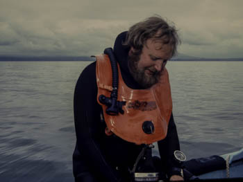
Northern Ireland Sublittoral Survey (NISS), 1982–86: The Department of the Environment for Northern Ireland (DOE NI) commissioned a diving team based at the Ulster Museum to carry out a sublittoral survey to assess potential areas for designations as Marine Nature Reserves (MNRs). The survey was under the overall direction of David Erwin (Ulster Museum’s Keeper of Botany & Zoology) with Bernard Picton supervising the fieldwork team which also included Christine Howson and David Connor. This was the first survey of its kind to be undertaken at such a large scale anywhere in the UK or Ireland.
 |
 |
 |
 |
| David Erwin | Christine Howson | David Connor | Bernard Picton & Christine Howson |
Northern Ireland Littoral Survey (NILS), 1984–88: The (DOE NI) commissioned a team from the Institute of Offshore Engineering of Heriot-Watt University consisting of Martin Wilkinson, Ian Fuller, Trevor Telfer, Colin Moore and Paul Kingston to carry out an intertidal marine nature conservation review. The aim of these two projects was to equip DOE NI with the data required to make informed decisions regarding areas around the coasts of Northern Ireland that merit protection as Marine Nature Reserves (MNRs) as required by the Nature Conservation and Amenity Lands (NI) Order, 1985.
Strangford Lough Ecological Change Investigation (SLECI), 2003–04: The Environment and Heritage Service (DOE NI) commissioned Queen’s University Belfast to investigate the different communities at various locations within Strangford Lough to allow for comparisons with historical records and to provide ground-truthing for broadscale habitat mapping which was being carried out as part of the same project. The survey team included Dai Roberts, Carys Davies, Annika Mitchell, Heather Moore, Bernard Picton, Alex Portig, Jane Preston, Matt Service, Dave Smyth, James Strong and Sam Vise.
Sponge Biodiversity of Rathlin Island, Northern Ireland, 2007: Bernard E. Picton (Ulster Museum Curator of Marine Invertebrates) received funding from the EU Building Sustainable Prosperity programme to survey the rich sponge diversity of Rathlin Island. Claire E. Goodwin was employed to work alongside Bernard E. Picton, the fieldwork team were assisted by Jen Jones, Anne-Marie Mahon and Louise M. Scally.
Sublittoral Survey Northern Ireland (SSNI), 2006–2012: the Department of Agriculture Environment and Rural Affairs (DAERA) scientific diving team (Joe Breen & Hugh Edwards) in partnership with the staff from the Ulster Museum (Bernard E. Picton & Claire E. Goodwin) undertook extensive diving surveys to assess the condition of existing Marine Protected Areas (MPAs) as well as identifying potential additional MPAs.
Mapping
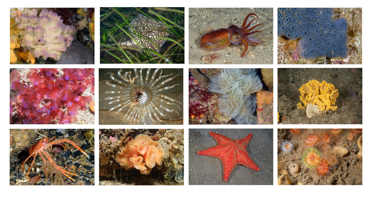
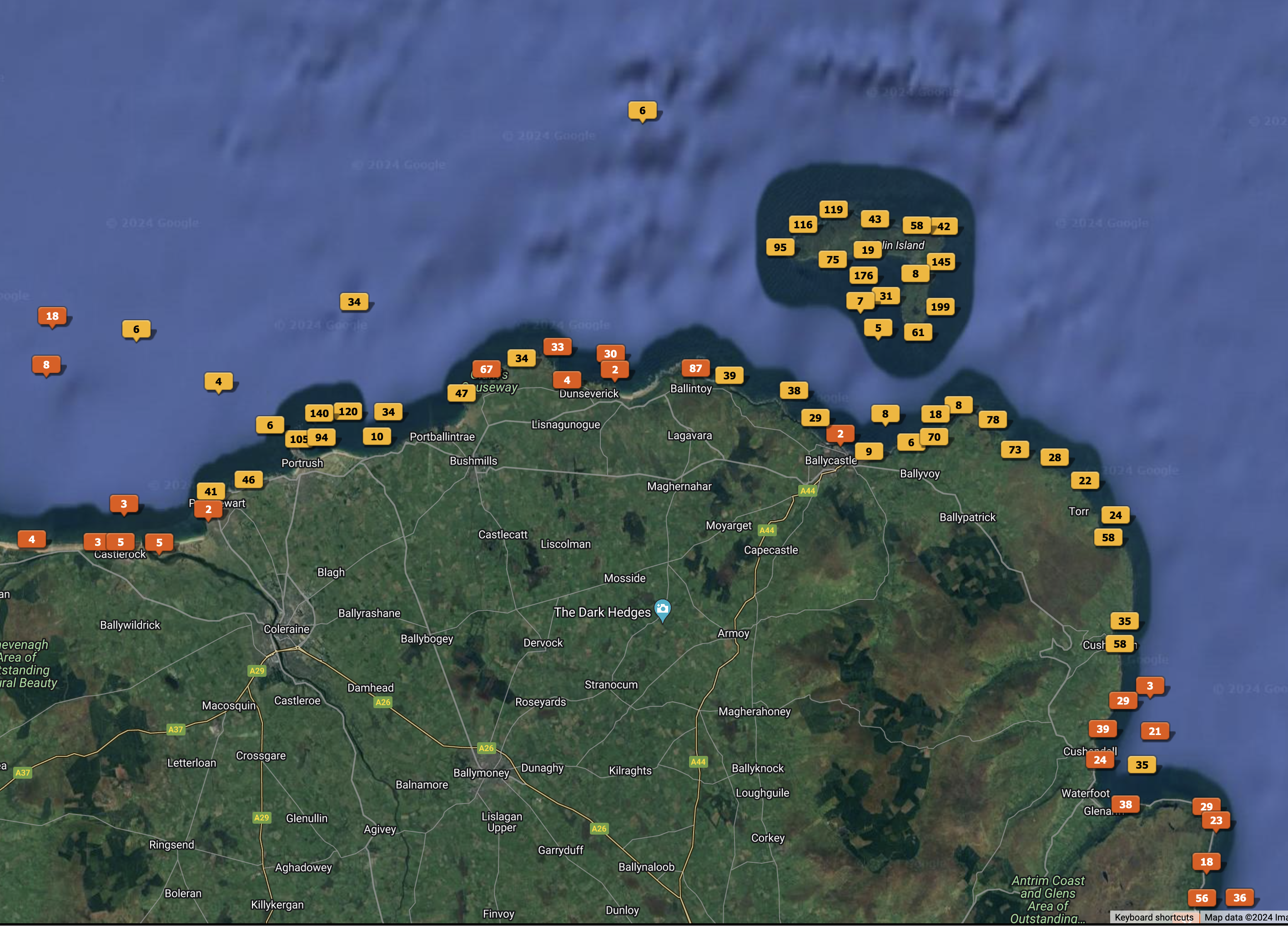
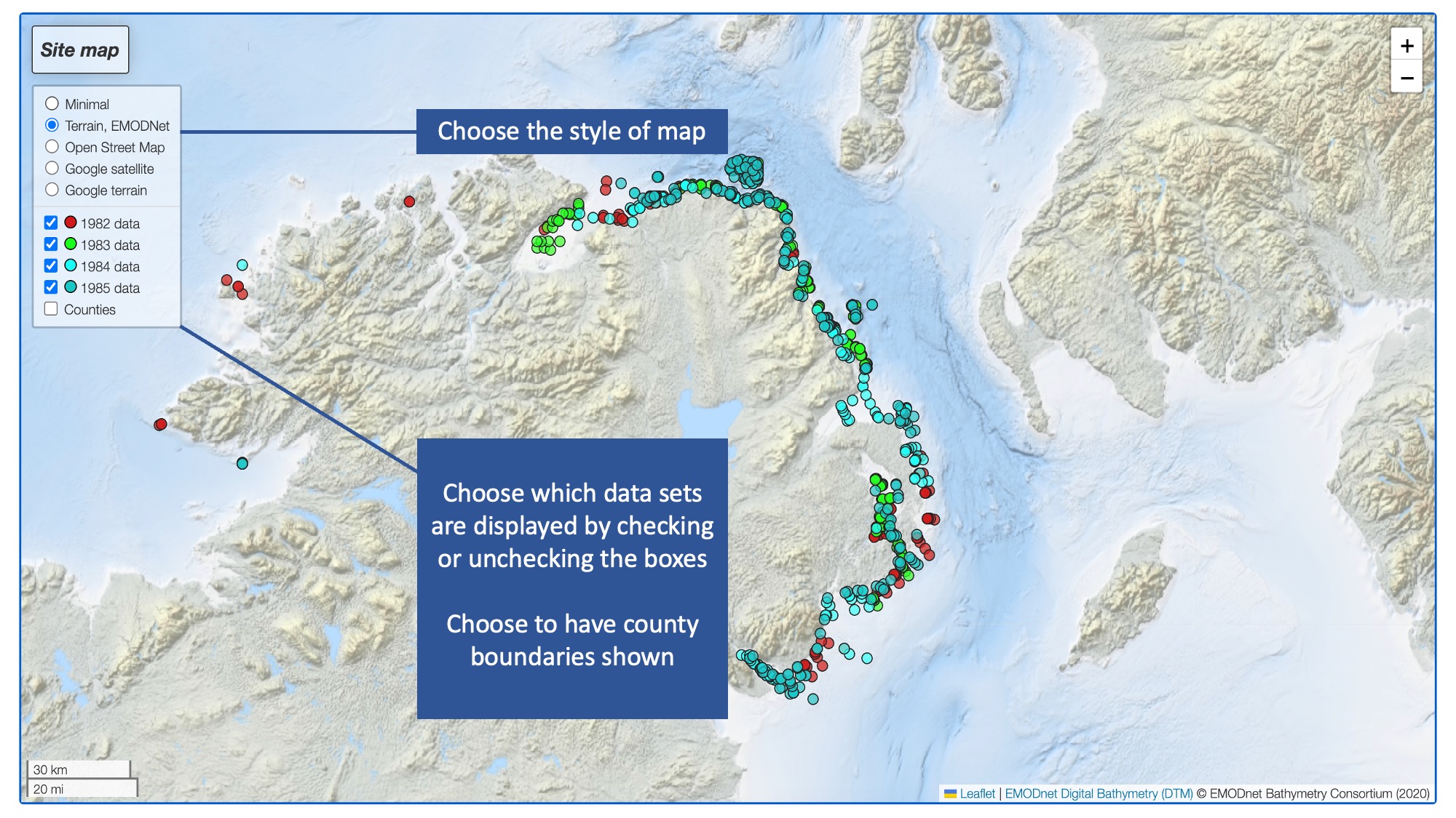
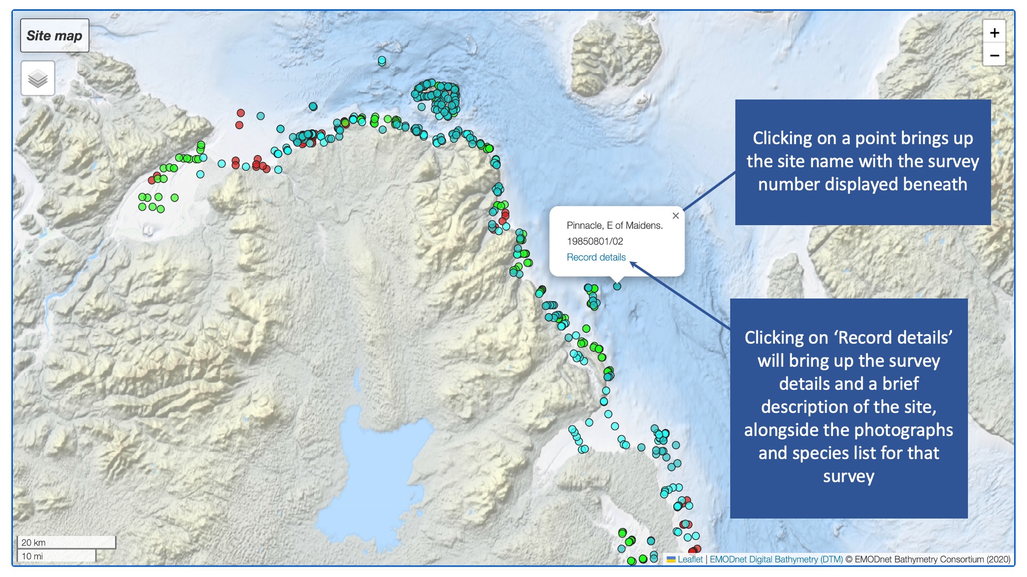
The surveys are displayed as GIS layers, initially on an EMODnet seabed bathymetry layer with a choice of other map layers. By clicking on a site, a pop-up will appear with site name, record number and ‘Record details’ as a hyperlink. Selecting ‘Record details’ takes the user to a webpage that displays site name, survey number, latitude-longitude, photographs, available video as well as an interactive species list for that site. Each species name can be clicked on, and this will take the user to the account for that species on the Encyclopedia of Marine Life of Britain and Ireland. All photographs are captioned with species name and photographer attributes. In addition to accessing the site and associated imagery from the map, there is also an interactive list of survey sites that can be viewed chronologically or alphabetically.

Species Accounts
The Encyclopedia of Marine Life of Britain & Ireland is now incorporated in MBDP-NI. The species pages will be further developed to cover additional species and updated with new images, additional information, distribution maps brought in from NBN Atlas and links to DNA barcodes when available.
For several of the groups the information has appeared in print in a series of guides produced by the editors and other members of the Marine Conservation Society. The authorship and sources are given below. By combining this information in a website it has been possible to make links across groups where appropriate, for instance between nudibranchs and the particular species of animals which they feed on. In addition some of the large photographs which are loaded when a user clicks on the photograph for a species are image maps, and other species in the photograph are linked to their own pages. Much of this material has already been published on the BioMar viewer CD-ROM and on the Species Directory CD-ROM (Picton & Howson, 2000), (Marine Conservation Society and Ulster Museum).
For convenience of users browsing on a tablet or smartphone the large images now have hotspots; top-left returns to the text account, mid-left to previous image and mid-right to the next image.
| Sponges | Original - Christine C. Morrow & Bernard E. Picton |
| Hydroids | Original - Bernard E. Picton & Christine C. Morrow |
| Anthozoans | Manuel, R.L., 1980. The Anthozoa of the British Isles - a colour guide. Produced for the Underwater Conservation Society by R. Earll. |
| Worms | Bernard E. Picton & Christine C. Morrow |
| Crustaceans | Libby Keatley, Bernard E. Picton & Christine C. Morrow |
| Molluscs | A field guide to the Nudibranchs of the British Isles - Bernard E. Picton & Christine C. Morrow, 1994. Immel Publishing, London |
| Bryozoans | Original - Bernard E. Picton & Christine C. Morrow |
| Echinoderms | A field guide to the shallow-water Echinoderms of the British Isles - Bernard E. Picton, 1993. Immel Publishing, London |
| Sea Squirts | Bernard E. Picton, 1985. Ascidians of the British Isles - a colour guide. Marine Conservation Society |
| Fishes | Original - Christine C. Morrow & Bernard E. Picton |
| Seaweeds | Original - Osborne Morton & Bernard E. Picton |
| References | |
| Picton, B.E. and Costello M. J. (eds). 1998. BioMar biotope viewer: a guide to marine habitats, fauna and flora of Britain and Ireland. Environmental Sciences Unit, Trinity College, Dublin. ISBN 0 9526 735 4 | |
| Picton, B.E. & Howson, C.M. (eds) 2000. The species directory of the marine fauna and flora of the British Isles and surrounding seas. Ulster Museum and The Marine Conservation Society, Belfast and Ross-on-Wye. CD-ROM Edition. | |
Video
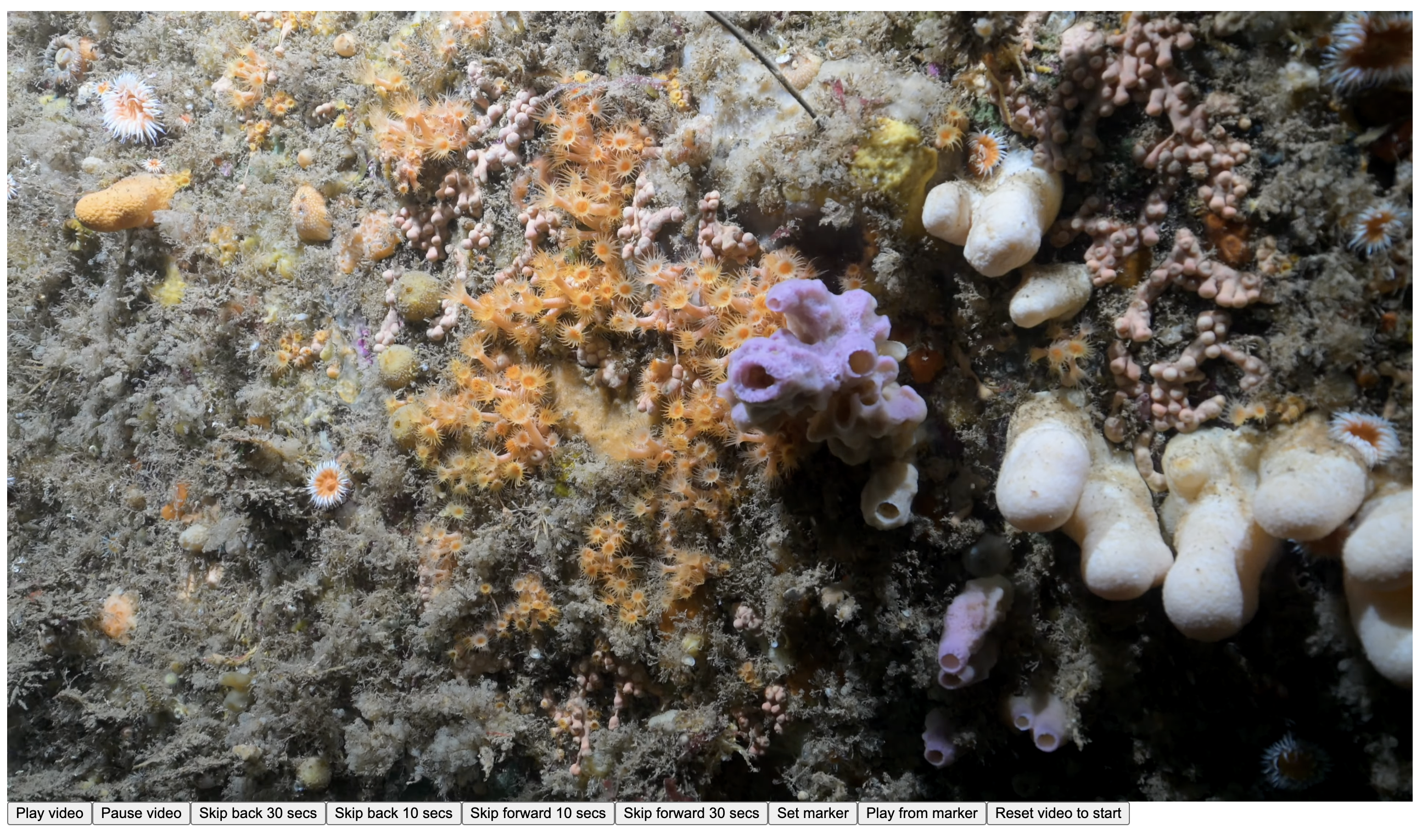
Videos of habitats and species are edited in Adobe Premiere Pro and are stored on YouTube. A tab "Highlights" contains an accompanying section of descriptive text that allows the user to skip to particular species or other features of interest within the video. The videos are uploaded to the project’s YouTube channel but will play within the website. There is a control panel that allows the user to play, pause, skip back 10 or 30 seconds, skip forward 10 or 30 seconds, or set a marker and then play from that marker as well as reset the video to start.
Northern Ireland Priority Species (NIPS)
There will be an interactive list for current marine NIPS that can be viewed taxonomically or alphabetically (either by scientific name or common name). Entry to the individual webpages for each species can also be done by phylum by selecting a photograph that is representative for that group. Each species page will include photographs, descriptions, maps brought in from NBN Atlas Northern Ireland, action plans and links to DNA barcodes on open access DNA databases.
Marine Non-Native Species
Similar to the NIPS pages, there will be an interactive list of marine non-native species and each species account will contain photographs, descriptions, maps from NBN Atlas Northern Ireland, action plans and links to DNA barcodes.
Volunteer Engagement
As part of MBDP-NI we have set up a project on iNaturalist to collate volunteer images and species records from Northern Irish waters. Verified records go to CEDaR for additional verification and then to NBN Atlas. Newly acquired, high resolution photographs, video and photogrammetry captured by volunteers will contribute to our knowledge of the current distribution of species and the status of seabed habitats. The collation of archive and recent imagery will facilitate future marine monitoring. High resolution photographs, video and photogrammetry of seabed habitats will be a powerful resource to engage wider audiences and promote awareness of Northern Ireland’s marine habitats and species.
DNA Barcoding
DNA barcoding is a method for identifying species using a short, standard fragment of DNA (usually mitochondrial COI), that is unique for most species. These DNA barcodes can then be compared against a reference library of barcodes to provide an identification. Whilst DNA barcodes are available for most marine fish and mammals, and there is little dispute regarding the taxonomic status of species within these groups, the same cannot be said for our marine invertebrates. This project will focus on obtaining DNA barcodes from well curated specimens, accompanied by high quality photographs to help build identification resources. There will be a particular focus on species that are of interest from a conservation perspective (Northern Ireland Priority Species); species that are potential non-natives or could be confused with non-native species and species where there is uncertainty over their taxonomic status. These barcodes will also facilitate future monitoring of species of concern using environmental DNA. The DNA sequencing is carried out by the Canadian Centre for DNA Barcoding and details of the specimens along with the DNA barcodes are available on the Barcode of Life Data System. The specimens from this project will be deposited in the Natural Sciences Collections of the National Museums Northern Ireland.

| 
| 
| 
|