Earth Science Conservation Review
| Ballysudden, Cookstown | Tyrone |


| Site Type: | Quarry (working) |
| Site Status: | ASSI |
| Council area: | Cookstown District Council |
| Grid Reference: | H8075 |
| Google maps: | 54.61731,-6.76163 |
| Rocks | |
|---|---|
| Rock Age: | Carboniferous (Asbian, Brigantian, Visean) |
| Rock Name: | Armagh Group, Rockdale Limestone Formation |
| Rock Type: | Limestone, Sand, Sandstone, Shale |
| Interest | |
| Fossil Groups: | Alga, Brachiopod, Coral, Crinoid, Foraminifera, Microfossil, Microfossils |
| Other interest: | palaeokarst, Aeolian sediment, Marine sediments, shelf |
Summary of site:
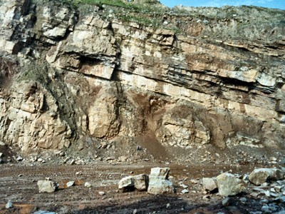
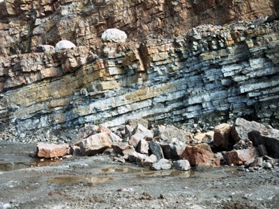
This operational cement works quarry is cut into a sequence of predominantly limestone beds, with some sandstones and shales. The entire section is inclined 15º to the north and a thickness of over 100m of lightly faulted beds can be seen. It is the best section of late Visean Carboniferous rocks of the Asbian and Brigantian stages to be seen anywhere in Northern Ireland. It also shows a range of features associated with wide and frequent fluctuations of sea level throughout this period of around 7 million years.
The oldest rocks (at the southern end of the quarry) start with a thin sandstone overlain by a sequence of around 60m of limestones broken by horizons of red shale with pale brown and purple stained sandstones. The limestones formed in shallow, tropical seas, teeming with life - particularly corals, brachiopods and countless millions of microscopic, single-celled foraminifera. In fact, the rocks are largely composed of the shells and skeletons of such creatures. There is also much evidence that some animals ploughed, burrowed and swept these soft sediments in a constant search for food particles.
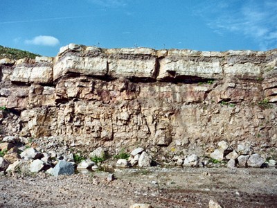
These lime sands appear to have hardened quite quickly once burial had put them beyond the reach of burrowing animals because the usually thin beds of shales and sandstones are undoubtedly soils, normally standing on hard limestone surfaces and obviously weathered in the open air. This particular kind of karst weathering is only found on solidified limestones.
There are at least four levels of soil development in the lowest 60m of the quarry, which means that the seabed was raised above sea level for long enough to be deeply weathered and for soils to accumulate on at least four occasions. In one place the working quarry face has cut through a substantial fossil pothole in the topmost of these levels, with a minimum depth of 15m. Since potholes can only form above the water table, sea level must have fallen by a minimum of 15m, probably much more, so these were not minor events. This pothole was not only created in this emergence but appears to have been exposed for long enough to become inactive. It was completely filled with wind-blown dust before being submerged by a further encroachment of the sea. We know this because the next layer of lime mud formed a continuous bed over the aperture of the pothole.
The visible and microscopic fossils found in this group of limestones indicate that both early and late Asbian rocks are present, representing a period of 3 or 4 million years.
Above this lower section a further 50m of rock can be seen, commencing with 9m of sandstone before again reverting to shallow water limestones formed at the level where sediment can be disturbed by wave action. There are at least four further palaeokarst surfaces (levels of weathering and soil formation) in these rocks that extend to the upper rim of the quarry. The thickest is 3m deep, immediately above the sandstone.
The age of the beds from the sandstone upwards is problematic because although there are plenty of fossils (both visible and microscopic), none is age diagnostic. There are a few specimens in these late Asbian rocks, below the sandstone, that hint at the proximity of the Brigantian (the stage following the Asbian); several corals in the limestones above suggest a Brigantian age but these are also found in the Asbian. The first certain Brigantian fossils occur 8m below the rim of the quarry. Despite the uncertainty, the thick sandstone at the base of this group is taken as the top of the Asbian and the base of the Brigantian, the argument being that it must represent a major change of conditions.
The overall picture presented by the rocks at this site is of a shallow, wave-swept shelf immediately off shore on the southern fringe of the Laurentian continent. The continent itself appears to have been a hot, barren desert. In contrast, the warm coastal seas thronged with a rich variety of animals, especially brachiopods, corals and a wealth of planktonic foraminifera. Sea level fluctuated widely, periodically laying bare the sea bed which weathered deeply to form karst (limestone) landscapes, including large potholes. Thick soils accumulated and survived submergence to be buried beneath new lime sediments. Despite the wealth of fossils, only a few are useful for dating - leaving something of a question mark over the exact position of the Asbian/Brigantian boundary.
The numerous special features of this quarry and the continuous depth of rocks exposed make it an exceptional site. Threats are those usual in working quarries, largely the changes in interest and the loss of some features as faces recede; in this case palaeokarst surfaces may be quarried away. When working ceases, flooding may follow but its ASSI status should protect against major ravages such as landfill.
| Enlander, I., Dempster, M. & Doughty, P., 2025. Ballysudden, Cookstown, County Tyrone, site summary. [In] Earth Science Conservation Review. https://www.habitas.org.uk/escr/summary.php?item=280. Accessed on 2025-04-03 |
| Previous Site | Next Site |

