Earth Science Conservation Review
| Moffatt's Quarry, Drumquin | Tyrone |
| Site Type: | Quarry (working) |
| Site Status: | local interest |
| Council area: | Omagh District Council |
| Grid Reference: | H3171 |
| Google maps: | 54.58677,-7.52049 |
| Rocks | |
|---|---|
| Rock Age: | Carboniferous (Visean) |
| Rock Name: | Ballyshannon Limestone Formation, Bundoran Shale Formation, Ederny Limestone Member, Tyrone Group |
| Rock Type: | Limestone, Shale |
| Interest | |
| Fossil Groups: | Arthropod, Bivalve, Brachiopod, Coral, Crinoid, Plant, Polyzoan |
Summary of site:
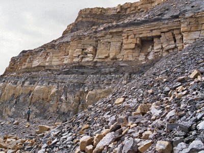
This line of quarries on the east and north faces of Dunnaree Hill, south west of Drumquin, exposes the finest outcrops of the Bundoran Shale Formation to be seen in Northern Ireland. Only Moffatt's Quarry is currently working and it displays the longest and cleanest faces to be seen anywhere in Northern Ireland.
The quarry also exposes the upper levels of the Ballyshannon Limestone Formation, including its topmost member, the Ederny Limestone, succeeded by over 40m of Bundoran Shale which form the main interest. A normal fault crosses the quarry floor, lengthening the observed succession.
The base of the Bundoran Shale lies on the top undulating surface of the Ederny Limestone Member. The basal beds consist of 1.4m of barren grey siltstone and shaley mudstone, incorporating beds of fine lime mud with fenestrae (tiny voids filled with calcite, originally bubbles of trapped air) and rhizoliths (cavities formed by the decay of plant roots). Above these beds is a distinctive black horizon of siltstones and mudstones, 1.3m thick, passing upwards into the hard, thick beds of lime-rich siltstones with dark shales and mudstones typical of the Bundoran Shale. Within this succession are occasional very thin (5mm) limestones crowded with chonetid brachiopods. Larger brachiopods and a characteristic fauna of solitary corals with Michelinia (a simple colonial form) occur further up the succession and date the rocks as middle Arundian (around 344 million years old).
The basal beds were formed in, or slightly above, tidal waters (as indicated by the fenestrae and root cavities). This is a hostile environment for most aquatic invertebrates and explains the absence of fossils, but conditions marginally improved in the black muds that followed, as indicated by the few ostracods and bivalve molluscs able to survive. As the lime-rich silts, muds and thin shell layers started to predominate, crinoids became common and with them came rich faunas of brachiopods, specialised corals and moss animals, all indicating inshore shallow water marine conditions.
The working quarry will continue to provide extensive clean exposure and the need for a management plan will only arise if and when it closes.
| Enlander, I., Dempster, M. & Doughty, P., 2025. Moffatt's Quarry, Drumquin, County Tyrone, site summary. [In] Earth Science Conservation Review. https://www.habitas.org.uk/escr/summary.php?item=228. Accessed on 2025-04-03 |
| Previous Site | Next Site |
