Earth Science Conservation Review
| Mullaghcarbatagh | Tyrone |
| Site Type: | Crag, Crags |
| Site Status: | ESCR |
| Grid Reference: | H518949 |
| Google maps: | 54.79973,-7.19455 |
| Rocks | |
|---|---|
| Rock Age: | Precambrian (Dalradian) |
| Rock Name: | Dart Formation, Glenga Amphibolite Member, Southern Highlands Group |
| Rock Type: | Amphibolite, Conglomerate, Green beds, Microconglomerate, Psammite |
| Interest | |
Summary of site:
Mullaghcarbatagh and its neighbouring summits of Oughtnager to the west and Mullaghclogher to the east, form the western termination of the central spine of the Sperrin Mountain ridge. The slopes and summits of these hills intermittently expose ancient Dalradian rocks of the Dart Formation.
The Dalradian rocks are among the oldest in Northern Ireland and were formed between 610 and 595 million years ago. They are divided into two major groups, the Argyll Group at the base and the Southern Highland Group above. The Dart Formation is the earliest of four in the Southern Highland Group and the lower of its two subdivisions, the Glenga Amphibolite Member is best seen here.
In the area from just east of Butterlope Glen to the summit of Mullaghcarbatagh the whole succession from the Dungiven Limestone at the top of the Argyll Group, through the Glenga Amphibolite Member and into the Henry's Bridge Member, both of the Dart Formation, are exposed. The type locality for the Glenga Amphibolite is in the Glega area immediately south and east of the Glen. A type locality is the area where a formation is defined because it shows its most important characteristics and usually defines its base. Most formations are named from the local geography of the type area.
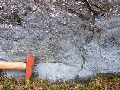
Around the Bradkeel Road on the southern slopes of Oughtnager there are many outcrops of green schists owing their colour to the amphibole minerals they contain, particularly actinolite and hornblende. Although now altered by metamorphism, the rocks were originally volcanic ashes mixed with sandy sea floor sediments. Overall the rock appears silky and contains quartz segregations that appear as parallel, white rods created in the stress of metamorphism.
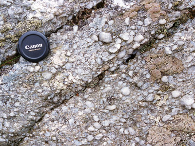
Outcrops on the slopes and summit of Oughtnager reveal thick conglomerates consisting of tiny pebbles of milky white quartz and pinkish feldspar in a fine matrix of similar composition. There are also grit beds throughout the succession. An interesting feature of these rocks is the miniature sausage shape of many of the pebbles caused by the stretching of the rock during metamorphism. Some beds show a sedimentary structure called graded bedding formed when a flow of sediments of mixed grain-size settled in deeper water. Because coarse grains settle first, the grain size decreases towards the top of the bed, indicating its way up. On Oughtnager the beds are clearly upside down. All these quartz-rich rocks are part of the Henry's Bridge Member which forms the major hills along the axis of the Sperrins to the east.
Towards the summit of Mullaghcarbatagh a band of dark green schist over 100 m thick is seen in many outcrops associated with areas of finer, paler, banded schists predominantly of feldspar and lime. These were formerly lavas probably erupted onto the Dart Formation sea bed and buried by later sediments.
Most of the rocks of the Henry's Bridge Member are altered sandstones and grits (quartz-rich) but there are also graphite schists (graphite is a pure form of carbon) and are seen in many outcrops across the higher slopes of Mullaghcarbatagh and Mullaghclogher
All these rocks were formed a little over 600 million years ago in ocean basins along a zone of structural instability very near the South Pole. The rocks of the earlier Argyll Group were formed in shallow water along extensive shelves adjacent to land but as stresses thinned the crust at the start of Southern Highland Group times, volcanic rocks broke through as new ocean basins subsided and filled with coarse sands washed off the surrounding barren land. The volcanic dusts of the Glenga Amphibolite Member mark that change and the base of the Dart Formation and the later lavas form good marker beds within the Henry's Bridge Member which completes the formation.
The sediments and volcanics were metamorphosed much later, between 470 and 465 million years ago during a massive continental collision and it was this event that heated and compressed these rocks causing all the structural features of the area including the stretched pebbles, the quartz rods, the cleavages (closely spaced fractures) and the folding, including the massive Sperrins Fold over 25 km across. It was overturned to the south which accounts for the inversion of the rock succession in this area.
As the stratotype of the Glenga Amphibolite Member, an important phase in the geological history of Northern Ireland, this entire area should be protected but as key exposures used in the comparison of the Middle and Upper Dalradian in Northern Ireland and Scotland it has international importance that must also be safeguarded.
Since this is a large area of wild, open, upland landscape it is difficult to imagine any major threat to its geological importance.
| Enlander, I., Dempster, M. & Doughty, P., 2025. Mullaghcarbatagh, County Tyrone, site summary. [In] Earth Science Conservation Review. https://www.habitas.org.uk/escr/summary.php?item=132. Accessed on 2025-04-03 |
| Previous Site | Next Site |

