Earth Science Conservation Review
| Mournes - Kilbroney River Section | Down |
| Site Type: | Stream section |
| Site Status: | ASSI |
| Council area: | Newry & Mourne District Council |
| Grid Reference: | J207221 |
| Google maps: | 54.13426,-6.15338 |
| Rocks | |
|---|---|
| Rock Age: | Tertiary (Eocene) |
| Rock Name: | Granite |
| Rock Type: | Granite |
| Interest | |
| Other interest: | ring-dyke, xenoliths, Contact, Intrusion, Farm land, grazing. |
Summary of site:
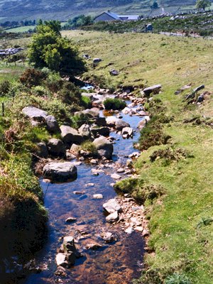
Each of the five granites of the Mourne Mountains appears to have cooled before the next was intruded resulting in razor sharp contacts between them but in the Kilbroney river bed, downstream of the road bridge, an exposure of the contact between granites G4 and G5 shows a gradation from one to the other. G5 shows coarse-grained texture with some larger, well-formed crystals (porphyritic texture) and patches crowded with large crystals of quartz and feldspar. These patches range from 10 cm to several metres across and are restricted to a narrow zone along the contact.
The coarsely crystalline patches are altered masses of G4. Fine-grained veins exploit crystal boundaries, separating individual crystals and larger fragments and creating a mantle around them which grades into the enclosing G5. It seems likely that G4 was relatively cold and solid before G5 was intruded so it was the activity and mobility of G5 along the junction that caused blocks of the older granite to detach.
As an example of gradation between Mourne granites this locality is important and perhaps unique.
| Enlander, I., Dempster, M. & Doughty, P., 2025. Mournes - Kilbroney River Section, County Down, site summary. [In] Earth Science Conservation Review. https://www.habitas.org.uk/escr/summary.php?item=1107. Accessed on 2025-04-03 |
| Previous Site | Next Site |
